Jemez Mountains
| Jemez Mountains | |
|---|---|
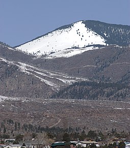
 Chicoma Mountain, the highest peak of the Jemez | |
| Highest point | |
| Peak | Chicoma Mountain |
| Elevation | 3,524 m (11,562 ft)[1] NAVD 88 |
| Coordinates | 36°00′26″N 106°23′04″W / 36.00722°N 106.38444°W |
| Geography | |
| Country | United States |
| State | New Mexico |
| Topo map | USGS Polvadera Peak (1977) |
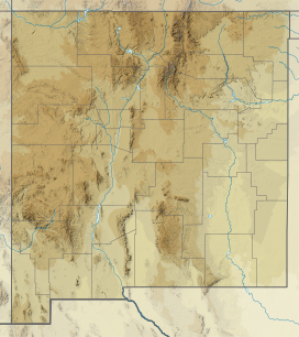
The Jemez Mountains (/ˈheɪmɛz/, Tewa: Tsąmpiye'ip'įn, Navajo: Dził Łizhinii) are a group of mountains in Rio Arriba, Sandoval, and Los Alamos counties, New Mexico, United States.
Numerous Puebloan Indian tribes have lived in the Jemez Mountains region for centuries before the Spanish arrived in New Mexico. The Pueblo Nations of this region are the Towa-speaking Jemez people, after whom the mountain range is named, and the Keres-speaking Zia People. Pueblos in the Jemez Mountains of New Mexico consisted of compact multistoried buildings which enclosed small plazas. Most of their several hundred rooms were probably occupied by single families, but some were storerooms.[2]
The Jemez Mountains encounter a semi-arid mountain climate of the continental type, as indicated by the U.S. Department of Energy in 1979. However, this classification conceals a significant amount of diversity linked to gradients in elevation and the region's topographical features.[3] The highest point in the range is Chicoma Mountain (also spelled as Tschicoma or Tchicoma) at an elevation of 11,561 feet (3,524 meters). The town of Los Alamos and the Los Alamos National Laboratory adjoin the eastern side of the range while the town of Jemez Springs is to the west. Pajarito Mountain Ski Area is the only ski area in the Jemez. New Mexico State Highway 4 is the primary road that provides vehicular access to locations in the Jemez Mountains.
Geology
[edit]The Jemez Mountains lie in north-central New Mexico, to the north of the Albuquerque Basin in the Rio Grande rift,[4] and span altitudes from 1,590 meters at the Rio Grande to 3,526 meters at the peak of Tschicoma Peak. This geological demarcation encompasses approximately 543,522 hectares, according to Smith et al.'s 1976 study.[3] They are a classic example of intracontinental volcanism and consist of a broadly circular ridge surrounding the Valles Caldera. The latter is the type location for resurgent caldera eruptions.[5]
The mountains lie on the intersection of the western margin of the Rio Grande Rift and the Jemez Lineament.[6][7] Here magma produced from the fertile rock of an ancient subduction zone has repeatedly found its way to the surface along faults produced by rifting. This has produced a long-lived volcanic field, with the earliest eruptions beginning at least 13 million years ago[8] and continuing almost to the present day. The most recent known eruption is the obsidian of the Banco Bonito flow, dated to 68.3 ± 1.5 thousand years before the present.[9]
Most of the volume of the range is composed of pre-caldera basalts, andesites, and dacites of the Keres Group and Polvadera Group, but there are extensive outflow sheets of the Bandelier Tuff[10] and young rhyolites associated with caldera resurgence, all assigned to the Tewa Group.[11][12][13][8]

The two most recent caldera-forming eruptions, dated to about 1.62 million and 1.256 million years ago,[14] produced massive ignimbrite deposits known as the Otowi and Tshirege members, respectively, of the Bandelier Tuff.[15] Much of the material in these deposits now forms the Pajarito Plateau, a scenic region of canyons and mesas on which Los Alamos is situated. Redondo Peak, the second-highest summit in the range at 11,254 ft (3431 m), is a resurgent dome in the middle of the Valles Caldera, which also contains several smaller volcanos. In the Jemez Mountains, the Quaternary volcanic field, encompasses the Valles caldera and the connected Bandelier Tuff.[16] The caldera is segregated by these structures and its rim into multiple lush grass valleys (valles in Spanish, hence the name).
The western part of the Valles Caldera is underlain by a seismic low-velocity zone with an area of 10 by 14 kilometers (6.2 by 8.7 mi) and extending to depths of 5 to 15.5 kilometers (3.1 to 9.6 mi). This zone consists of at least 10% molten rock and represents a new pulse of magmatic activity. This is monitored by the Los Alamos Seismic Network, which has detected no unusual volcano-seismic activity since it was installed in the 1970s.[17]
Public use
[edit]
Much of the range is federal land, including Santa Fe National Forest, Bandelier National Monument, and the Valles Caldera National Preserve. State lands include Fenton Lake State Park[18] at 35°52′58″N 106°43′46″W / 35.88278°N 106.72944°W in Sandoval County. Hiking trails crisscross the range and lead to many of the summits, although some regions are closed to hikers either because of environmental restrictions or because they are on the territory of Santa Clara Pueblo or private landholders. (Access to pueblo lands is available by permit.) The summits are generally easy to climb (in good weather) and require no technical climbing skills, but rock climbing is popular on some of the basalt cliffs near Los Alamos, Caja del Rio and elsewhere in the range. There are several hot and cold springs throughout the mountains, including the popular Spence Springs and Seven Springs, as well as Soda Dam. There are five official established campsites in the mountains, and many additional locations for backpackers as well. Another popular recreational activity is fishing in the Jemez River and San Antonio Creek. The mountains also are home to Pajarito Mountain, a small downhill ski area. Cross country skiing and snowshoeing are available on trails in the winter. However, not every winter produces enough snow to support activities that require significant snowfall.[19] The region is prone to forest fires because of the tendency for spring weather to be dry and windy, creating conditions under which fires caused by human activities or lightning can spread rapidly. The Las Conchas Fire in 2011 was the most recent large wildfire. Parts of Los Alamos National Laboratory were also damaged, although none of the laboratory's special nuclear materials were threatened or released.
Historical communities
[edit]Around the early 14th century, the Towa people built pueblos in the Jemez Mountains. The pueblos include Unshagi, Nanishagi, and Giusewa pueblos. Before the arrival of the Spanish in the 17th century, the area was well-populated, and had established farming communities and trade systems. Outside of the pueblos, the ruins of around 300 small structures have been discovered. Potsherds have been found near a majority of the structures, and arrowheads have been found in many of the surrounding areas.[20]

When the Spanish began their colonization efforts in the 17th century, they heard the Towa word Hemes, meaning "the people." They then translated it to the Spanish spelling, Jemez. The Spanish forced the Towa living in Giusewa pueblo (the most significant pueblo of the region at the time) to abandon their traditional practice, and to adopt Catholicism. From the very beginning, the Jemez resisted the Spanish oppression, initiating two uprisings against them prior to the occurrence of the Pueblo Revolt in 1680.[21] After the Pueblo Revolt in 1680, the Spanish set about a campaign of reoccupation in 1692. the Towa were able to resist for longer because of the distance of the Jemez mountains from the Rio Grande Valley, which was where the main concentration of Spanish activity was. Giusewa was reoccupied in 1694, and revolted again in 1696. This revolt was ultimately a failure, and many Towa people sought refuge among the Navajo. In 1703, the majority of individuals had come back to the Jemez Valley, reconstructing their pueblo. In 1838, as Pecos Pueblo, a different village speaking Towa in the Galisteo Basin, was deserted, its seventeen inhabitants relocated to Jemez Pueblo.[21]
Modern communities
[edit]Census-designated places within the Jemez Mountains include Jemez Springs and Jemez Pueblo (referred to as Walatowa in Towa[22]). Jemez Springs is a small town with a population of 198 according to the 2020 census.[23] In the Jemez Pueblo, more than 90% of around 3400 members speak the Towa language.[24] Within this community, all decisions are made by the tribal government, which are heavily influenced by traditional connections to the Jemez land.[24] Increases in wildfires and bark-beetle outbreaks in the most recent decade are likely related to extreme drought and high temperatures during this period.[25]
Flora
[edit]There are over 720 plant species in the Jemez Mountain region with six community types that include, subalpine grassland, spruce-fir, mixed conifer, ponderosa pine, pinyon juniper, and juniper-grassland.[26] Adding a touch of color to the landscape are wildflowers like alpine larkspur, forget-me-nots, saxifrages, and sedges.[27] Ponderosa pine are found between 2100 and 2300 meters on the east side of the Jemez Mountains while mixed conifer forests are found between 2100 and 3200 meters in elevation.[26] Spruce-fir forests are mostly found at the summits of mountains due to suitable climate conditions.[26] Additionally, oak shrublands have emerged on certain mountain slopes and in high mountain meadows as a result of wildfires.[28] The San Pedro Parks Wilderness in the northwest region, White Rock Canyon along the Rio Grande, and the desert shrublands at the extreme southwest part of the Jemez Mountains, particularly capture attention due to their distinctive plant life.[29]
Fauna
[edit]
The Jemez Mountains house the American elk (wapiti), the golden-mantled ground squirrel, the Gunnison's prairie dog, American beavers, black bears, and mountain lions. The Jemez Mountains are also home to a federally endangered species, the Jemez Mountains salamander. This species is mostly found in mixed-conifer forests and was listed under the Endangered Species Act in 2013.[30] The Jemez Mountains salamander's habitat is in danger due to forest fires, increased tree density, the destruction of habitat, and climate change.[30]
References
[edit]- ^ "Langley". NGS Data Sheet. National Geodetic Survey, National Oceanic and Atmospheric Administration, United States Department of Commerce. Retrieved 2008-12-22.
- ^ Fliedner, Dietrich. "PRE-SPANISH PUEBLOS IN NEW MEXICO". Annals of the Association of American Geographers. p. 16.
- ^ a b Craig Daniel, Allen (1989). "Changes in the landscape of the Jemez Mountains, New Mexico". Scholarly Article.
- ^ Russell, L.R.; Nelson, S. (1990). "Structural Style and Tectonic Evolution of the Albuquerque Basin Segment of the Rio Grande Rift". In Pinet, Bertrand; Bois, Christian (eds.). The Potential of Deep Seismic Profiling for Hydrocarbon Exploration: Proceedings of the 5th IFP Exploration and Production Research Conference, Held in Arles, June 19-23, 1989. Paris: Editions TECHNIP. p. 178. ISBN 978-2-7108-0590-8. Retrieved 2012-09-30.
- ^ Smith, R.L.; Bailey, R.A. (1968). "Resurgent cauldrons". Memoir of the Geological Society of America. Geological Society of America Memoirs. 116: 613–662. doi:10.1130/MEM116-p613.
- ^ Aldrich Jr., M. J. (1986). "Tectonics of the Jemez Lineament in the Jemez Mountains and Rio Grande Rift". Journal of Geophysical Research. 91 (B2): 1753–1762. Bibcode:1986JGR....91.1753A. doi:10.1029/JB091iB02p01753.
- ^ Whitmeyer, Steven; Karlstrom, Karl E. (2007). "Tectonic model for the Proterozoic growth of North America". Geosphere. 3 (4): 220. doi:10.1130/GES00055.1.
- ^ a b Heiken, G; Goff, F; Gardner, J N; Baldridge, W S; Hulen, J B; Nielson, D L; Vaniman, D (May 1990). "The Valles/Toledo Caldera Complex, Jemez Volcanic Field, New Mexico". Annual Review of Earth and Planetary Sciences. 18 (1): 27–53. Bibcode:1990AREPS..18...27H. doi:10.1146/annurev.ea.18.050190.000331.
- ^ Zimmerer, Matthew J.; Lafferty, John; Coble, Matthew A. (January 2016). "The eruptive and magmatic history of the youngest pulse of volcanism at the Valles caldera: Implications for successfully dating late Quaternary eruptions". Journal of Volcanology and Geothermal Research. 310: 50–57. Bibcode:2016JVGR..310...50Z. doi:10.1016/j.jvolgeores.2015.11.021.
- ^ Ross, Clarence S.; Smith, Robert L. (1961). "Ash-flow tuffs: Their origin, geologic relations, and identification". USGS Profession Paper Series. Professional Paper (366). doi:10.3133/pp366. hdl:2027/ucbk.ark:/28722/h26b1t.
- ^ Smith, R.L.; Bailey, R.A.; Ross, C.S. (1969). "Stratigraphic Nomenclature of ' Volcanic Rocks in the Jemez Mountains, New Mexico" (PDF). Geological Survey Bulletin (1274-P). Retrieved 4 May 2020.
- ^ Kudo, A.M. (1974). "Outline of the Igneous Geology of the Jemez Mountains Volcanic Field". New Mexico Geological Society Field Conference Series (25): 287–289. CiteSeerX 10.1.1.515.9268.
- ^ Guilbeau, Kevin P.; Kudo, A. M. (1985). "Petrology and geochemistry of the Paliza Canyon Formation and the Bearhead Rhyolite, Keres Group, Jemez Mountains, New Mexico". Geological Society of America Bulletin. 96 (1): 108. Bibcode:1985GSAB...96..108G. doi:10.1130/0016-7606(1985)96<108:PAGOTP>2.0.CO;2.
- ^ Phillips, Erin H. (May 2004). Collapse and Resurgence of the Valles Caldera, Jemez Mountains, New Mexico: 40 Ar / 39 Ar Age Constraints on the Timing and Duration of Resurgence and Ages of Megabreccia Blocks (master's thesis). Socorro, New Mexico: New Mexico Institute of Mining and Technology. CiteSeerX 10.1.1.211.1475.
- ^ Dethier, David P.; Kampf, Stephanie K. (2007). Geology of the Jemez Region II. Ne Mexico Geological Society. p. 499 p. Archived from the original on 17 October 2015. Retrieved 6 November 2015.
- ^ https://search.ebscohost.com/login.aspx?direct=true&db=a9h&AN=27311062&site=ehost-live&scope=site
- ^ WoldeGabriel, Giday; Kelley, Rick; Miller, Elizabeth; Schultz-Fellenz, Emily (May 2016). "The Youngest Silicic Eruptions from theValles Caldera and Volcanic Hazard Potentialin North-central New Mexico" (PDF). New Mexico Geology. 38 (2): 263–274. doi:10.58799/NMG-v38n2.50. Retrieved 8 June 2021.
- ^ "Home". EMNRD. Retrieved 2023-03-11.
- ^ "Santa Fe - Jemez Ranger District". October 2, 2023.
- ^ Fliedner, Dietrich (1975). "Pre-Spanish Pueblos in New Mexico". Annals of the Association of American Geographers. 65 (3): 363–377. doi:10.1111/j.1467-8306.1975.tb01045.x. ISSN 0004-5608. JSTOR 2561887.
- ^ a b LouAnn Faris, Culley (2023). Eastern Pueblo Tribes. Salem Press Encyclopedia.
{{cite book}}: CS1 maint: location missing publisher (link) - ^ Waldman, C. (2022). Towa. In Encyclopedia of Native American Tribes, Fourth Edition. New York: Facts On File. Retrieved October 11, 2023, from online.infobase.com/Auth/Index?aid=104024&itemid=WE43&articleId=191001.
- ^ Bureau, US Census. "Search Results". The United States Census Bureau. Retrieved 2023-03-11.
{{cite web}}:|last=has generic name (help) - ^ a b Wallerstein, Nina; Duran, Bonnie M.; Aguilar, Jolene; Joe, Lorenda; Loretto, Felipita; Toya, Anita; Yepa-Waquie, Harriet; Padilla, Randy; Shendo, Kevin (September 2003). "Jemez Pueblo: Built and Social-Cultural Environments and Health Within a Rural American Indian Community in the Southwest". American Journal of Public Health. 93 (9): 1517–1518. doi:10.2105/AJPH.93.9.1517. ISSN 0090-0036. PMC 1448002. PMID 12948972.
- ^ Williams, A. Park (2010). "Forest responses to increasing aridity and warmth in the southwestern United States". Proceedings of the National Academy of Sciences of the United States of America. Vol. 107.
- ^ a b c Gardner, Shelly L.; Oswald, Brian P.; Farrish, Kenneth W.; Edminster, Karl (December 2003). "Community classification within three vegetative zones of the East side of the Jemez Mountains, New Mexico". New Mexico Journal of Science. 43 (1): 25+ – via Gale Academic OneFile.
- ^ McGivney, Annette (Aug 2001). "THE YELLOWSTONE OF THE SOUTHWEST". Science Reference Center – via EBSCOhost.
- ^ Keller, C. F.; Martin, C. T.; Foxx, T. S.; Greiner, N. R. (2017-11-29). "Additional species for the Jemez Mountains, New Mexico, U.S.A." Journal of the Botanical Research Institute of Texas. 11 (2): 513–522. doi:10.17348/jbrit.v11.i2.1088. ISSN 2644-1608.
- ^ \https://search.ebscohost.com/login.aspx?direct=true&db=a9h&AN=126524715&site=ehost-live&scope=site
- ^ a b Bartlow, Andrew W.; Giermakowski, J. Tomasz; Painter, Charles W.; Neville, Paul; Schultz-Fellenz, Emily S.; Crawford, Brandon M.; Lavadie-Bulnes, Anita F.; Thompson, Brent E.; Hathcock, Charles D. (August 2022). "Modeling the distribution of the endangered Jemez Mountains salamander ( Plethodon neomexicanus ) in relation to geology, topography, and climate". Ecology and Evolution. 12 (8): e9161. Bibcode:2022EcoEv..12E9161B. doi:10.1002/ece3.9161. ISSN 2045-7758. PMC 9399451. PMID 36035267.

