Zapatera
Appearance
(Redirected from Isla Zapatera)
| Zapatera | |
|---|---|
 | |
| Highest point | |
| Elevation | 629 m (2,064 ft)[1] |
| Coordinates | 11°44′N 85°49′W / 11.73°N 85.82°W[1] |
| Geography | |
| Location | Granada Department, Nicaragua |
| Geology | |
| Mountain type | Shield volcano |
| Last eruption | Unknown |
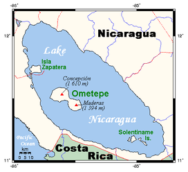
Zapatera is a shield volcano located in the southern part of Nicaragua. It forms the island of Isla Zapatera in the Lake Nicaragua. Isla Zapatera constitutes one of 78 protected areas of Nicaragua.
As of 1850, Zapatera was described "uninhabited" by British writer John Baily.[2] The archaeological site of Zapatera is located on the island.
See also
[edit]References
[edit]- ^ a b "Zapatera". Global Volcanism Program. Smithsonian Institution. Retrieved 2020-03-17.
- ^ Baily, John (1850). Central America; Describing Each of the States of Guatemala, Honduras, Salvador, Nicaragua, and Costa Rica. London: Trelawney Saunders. p. 156.

