Hyrcanis (Lydia)


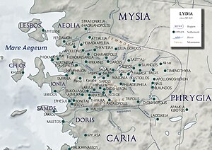
Hyrcanis or Hyrkaneis, also known as Hyrcania (Ancient Greek: Ὑρκανία), was a Roman and Byzantine-era city[1] and bishopric in ancient Lydia, now in western Turkey. It was situated in the Hyrcanian plain (τὸ Ὑρκάνιον πεδίον), which is said to have derived its name from a colony of Hyrcanians being settled here by the Persians.[2][3] They were afterwards mingled with some Macedonians, who also settled in this district, whence they are called by Pliny the Elder and Tacitus "Macedones Hyrcani."[4][5][6][7] The city minted its own coins.[8][9]
Its site is located west of Halit Paşa in Asiatic Turkey,[10][11] south of Çamlıyurt.
The city was also the seat of an ancient bishopric. Known bishops include:
- Asyncritus
- John, attendee at First Council of Constantinople
- Eustathius
- Dionysius fl.1157[12]
References
[edit]- ^ Ruth Lindner, Mythos und Identität: Studien zur Selbstdarstellung kleinasiatischer Städte in der römischen Kaiserzeit (Franz Steiner Verlag, 1994) p128.
- ^ Strabo. Geographica. Vol. xiii. p.629. Page numbers refer to those of Isaac Casaubon's edition.
- ^ Stephanus of Byzantium. Ethnica. Vol. s.v. Ὑρκανία.
- ^ Pliny. Naturalis Historia. Vol. 5.29.31.
- ^ Tacitus. Annales. Vol. 2.47.
- ^ "Titular See of Hyrcanis, Turkiye".
- ^ "Hyrcanis (Titular See) [Catholic-Hierarchy]".
- ^ Ancient Coinage of Lydia, Hyrkanis.
- ^ Hyrkaneis at Asia Minor Coins .
- ^ Richard Talbert, ed. (2000). Barrington Atlas of the Greek and Roman World. Princeton University Press. p. 56, and directory notes accompanying. ISBN 978-0-691-03169-9.
- ^ Lund University. Digital Atlas of the Roman Empire.
- ^ Michel Le Quien, Oriens christianus p887.
![]() This article incorporates text from a publication now in the public domain: Smith, William, ed. (1854–1857). "Hyrcania". Dictionary of Greek and Roman Geography. London: John Murray.
This article incorporates text from a publication now in the public domain: Smith, William, ed. (1854–1857). "Hyrcania". Dictionary of Greek and Roman Geography. London: John Murray.
- Catholic titular sees in Asia
- Defunct dioceses of the Ecumenical Patriarchate of Constantinople
- Dioceses established in the 1st century
- Ancient Greek archaeological sites in Turkey
- Populated places in ancient Lydia
- Roman towns and cities in Turkey
- Former populated places in Turkey
- Populated places of the Byzantine Empire
- History of Manisa Province
