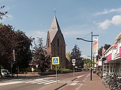
Heeze
Heeze | |
|---|---|
Town | |
 The Saint Martinus Church | |
| Coordinates: 51°22′57″N 5°34′6″E / 51.38250°N 5.56833°E | |
| Country | Netherlands |
| Province | North Brabant |
| Municipality | Heeze-Leende |
| Area | |
• Total | 45.96 km2 (17.75 sq mi) |
| Elevation | 24 m (79 ft) |
| Population (2021)[1] | |
• Total | 9,945 |
| • Density | 220/km2 (560/sq mi) |
| Time zone | UTC+1 (CET) |
| • Summer (DST) | UTC+2 (CEST) |
| Postal code | 5591[1] |
| Dialing code | 040 |
Heeze is a town in the Dutch province of North Brabant. It is located in the municipality of Heeze-Leende, about 9 km southeast of Eindhoven.
The Heeze Castle is located east of the town. Further east and to the north lies the Strabrechtse Heide.
History
[edit]The village was first mentioned in 1173 as Herebertus de Hese, and means shrubbery.[3] Heeze is an agricultural community which developed along the Grote and Sterkselse Aa.[4]
The heerlijkheid Heeze was first mentioned in 1172. A castle has been known since 1203. The current castle dates from the 15th century and enlarged and probably rebuilt in the 17th century. Between 1796 and 1798, a large English landscape garden was laid out around castle.[4][5]
Heeze was home to 1,814 people in 1840.[6] In 1913, a railway station was constructed on the Eindhoven to Weert railway line. It was closed in 1977, and a new railway station opened on a new location.[7][8]
Heeze was a separate municipality until 1997, when it merged with Leende.[9]
Transportation
[edit]Road
[edit]Heeze is located close to the A2 and A67 motorways. Local roads connect Heeze to the neighbouring towns of Geldrop, Someren, Sterksel and Leende.
Rail
[edit]The Heeze railway station is serviced by regional NS trains in the directions of Weert, Eindhoven and Tilburg.[10]
Gallery
[edit]-
Heeze Castle
-
Pub in Heeze
-
Brabantsedag 2019
-
Town hall
References
[edit]- ^ a b c "Kerncijfers wijken en buurten 2021". Central Bureau of Statistics. Retrieved 16 April 2022.
- ^ "Postcodetool for 5591AA". Actueel Hoogtebestand Nederland (in Dutch). Het Waterschapshuis. Retrieved 16 April 2022.
- ^ "Heeze - (geografische naam)". Etymologiebank (in Dutch). Retrieved 16 April 2022.
- ^ a b Chris Kolman & Ronald Stenvert (1997). Heeze (in Dutch). Zwolle: Waanders. ISBN 90 400 9945 6. Retrieved 16 April 2022.
- ^ "Middeleeuwen". Kasteel Heeze (in Dutch). Retrieved 16 April 2022.
- ^ "Heeze". Plaatsengids (in Dutch). Archived from the original on 27 August 2023. Retrieved 16 April 2022.
- ^ "station Heeze". Stationweb (in Dutch). Retrieved 16 April 2022.
- ^ "station Heeze (oud)". Stationweb (in Dutch). Retrieved 16 April 2022.
- ^ Ad van der Meer and Onno Boonstra, Repertorium van Nederlandse gemeenten, KNAW, 2011.
- ^ NS. "Station Heeze". Retrieved 6 July 2020.


