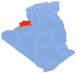
Hammaguir
Hammaguir | |
|---|---|
Village and air base | |
| Coordinates: 30°54′N 3°2′W / 30.900°N 3.033°W | |
| Country | |
| Province | Béchar Province |
| District | Abadla District |
| Elevation | 744 m (2,441 ft) |
| Time zone | UTC+1 (CET) |
Hammaguir (also written Hamaguir and Hammaguira) (Arabic: حماقير) is a village in Abadla District, Béchar Province, Algeria, south-west of Béchar. It lies on the N50 national highway between Béchar and Tindouf. The location is notable for its role in French rocketry.[1]
Hamaguir Airport is located there.[2]
Role in French rocketry and spaceflight
[edit]Between 1947 and 1967 there was a rocket launch site, the Interarmy Special Vehicles Test Centre (abbreviated CIEES in French), near Hammaguir, used by France for launching sounding rockets and the satellite carrier "Diamant" between 1965 and 1967. The Diamant launch pad at Hammaguir is located at 30° 46′ 41″ N, 3° 3′ 14″ W. The CIEES facility was also used for testing surface-to-air and air-to-air missiles.[3]
The first French satellite Astérix was launched from there in 1965.[3]
In honor of its role in the early development of French spaceflight, its name was given to a Martian crater in 1979[4] and to an asteroid crater in 2009.[5]
Notable Launches
[edit]| Date of launch | Satellite | Payload mass | Support rocket | References |
|---|---|---|---|---|
| 18 October 1963 | Félicette (cat) | 15 kg | Véronique | [6] |
| 26 November 1965 | Astérix-1 | 40 kg | Diamant | [1] |
| 8 February 1967 | Diadéme-1 | 22.7 kg | Diamant | [1] |
| 15 February 1967 | Diadéme-2 | 22.7 kg | Diamant | [1] |
Climate
[edit]Hammaguir has a hot desert climate, with extremely hot summers and cool winters, and very little precipitation throughout the year.
| Climate data for Hammaguir | |||||||||||||
|---|---|---|---|---|---|---|---|---|---|---|---|---|---|
| Month | Jan | Feb | Mar | Apr | May | Jun | Jul | Aug | Sep | Oct | Nov | Dec | Year |
| Mean daily maximum °C (°F) | 17.1 (62.8) |
20.3 (68.5) |
23.7 (74.7) |
28.4 (83.1) |
33.2 (91.8) |
38.0 (100.4) |
42.6 (108.7) |
41.2 (106.2) |
35.3 (95.5) |
28.8 (83.8) |
21.6 (70.9) |
17.6 (63.7) |
29.0 (84.2) |
| Daily mean °C (°F) | 9.8 (49.6) |
12.8 (55.0) |
16.2 (61.2) |
20.6 (69.1) |
25.3 (77.5) |
30.0 (86.0) |
34.3 (93.7) |
33.3 (91.9) |
27.9 (82.2) |
21.7 (71.1) |
15.0 (59.0) |
10.7 (51.3) |
21.5 (70.6) |
| Mean daily minimum °C (°F) | 2.5 (36.5) |
5.3 (41.5) |
8.8 (47.8) |
12.9 (55.2) |
17.4 (63.3) |
22.1 (71.8) |
26.1 (79.0) |
25.4 (77.7) |
20.6 (69.1) |
14.6 (58.3) |
8.5 (47.3) |
3.8 (38.8) |
14.0 (57.2) |
| Average precipitation mm (inches) | 5 (0.2) |
5 (0.2) |
7 (0.3) |
5 (0.2) |
4 (0.2) |
3 (0.1) |
3 (0.1) |
4 (0.2) |
6 (0.2) |
9 (0.4) |
11 (0.4) |
6 (0.2) |
68 (2.7) |
| Source: climate-data.org[7] | |||||||||||||
References
[edit]- ^ a b c d Wade, Mark. "Hammaguira". Astronautix. Archived from the original on September 7, 2016.
- ^ "Hamaguir Airport". OurAirports. Retrieved 12 March 2013.
- ^ a b "Le CIEES (Centre Interarmées d'Essais d'Engins Spéciaux)" (in French). Archived from the original on 15 January 2013. Retrieved 12 March 2013.
- ^ "Planetary Names: Crater, craters: Hamaguir on Mars". Gazetteer of Planetary Nomenclature. Working Group for Planetary System Nomenclature (WGPSN). November 17, 2010. Retrieved 28 April 2018.
- ^ "Planetary Names: Crater, craters: Hammaguira on Itokawa". Gazetteer of Planetary Nomenclature. Working Group for Planetary System Nomenclature (WGPSN). June 15, 2010. Retrieved 28 April 2018.
- ^ Jouin, Georges (15 November 1963). Félicette, la 1ère chatte astronaute (Video) (in French). Radiodiffusion-Télévision Française. Retrieved 16 May 2018.
- ^ "Climate data for: Hamaguir". climate-data.org. Retrieved 12 March 2013.


