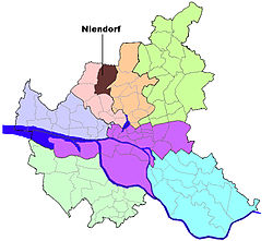
Niendorf, Hamburg
Niendorf | |
|---|---|
 Niendorf market area (pedestrian zone) | |
| Coordinates: 53°37′04″N 9°57′01″E / 53.61778°N 9.95028°E | |
| Country | Germany |
| State | Hamburg |
| City | Hamburg |
| Borough | Eimsbüttel |
| Area | |
• Total | 12.7 km2 (4.9 sq mi) |
| Population (2023-12-31)[1] | |
• Total | 42,332 |
| • Density | 3,300/km2 (8,600/sq mi) |
| Time zone | UTC+01:00 (CET) |
| • Summer (DST) | UTC+02:00 (CEST) |
| Dialling codes | 040 |
| Vehicle registration | HH |
Niendorf () is one of 105 quarters of Hamburg, Germany in the Eimsbüttel borough. In 2020 the population was 40,906.
Geography
[edit]According to the statistical office of Hamburg and Schleswig-Holstein, the quarter has a total area of 12.7 km² .
Demographics
[edit]In 2006 in the quarter Niendorf were living 39,690 people. 15.2% were children under the age of 18, and 24.8% were 65 years of age or older. 6.9% were immigrants. 1,140 people were registered as unemployed.[2]
In 1999 there were 20,092 households and 40.5% of all households were made up of individuals.[3]
Education
[edit]There were 5 elementary schools and 4 secondary schools in Niendorf,[4] including the Gymnasium Ohmoor. The public secondary school Gymnasium Ohmoor participates in the U.S. Congress - Bundestag Youth Exchange Program.[5] The exchange program provides 250 full scholarships for American high school students, to let them "gain real world views of current affairs and German social, political and economic life." (Quoted official website http://www.usagermanyscholarship.org/). Other secondary schools include the Gymnasium Bondenwald and the Stadteilschule Niendorf.
Infrastructure
[edit]Health systems
[edit]In 2006 71 physicians in private practice and 10 pharmacies were counted.[4]
Transportation
[edit]Public transport is provided by the Hamburger Verkehrsverbund with several stations of the underground railway and bus lines. The Niendorf Nord railway station is the terminus of the line U2.
The Bundesstrasse 447 pass the quarter connecting the Bundesstrasse 5 with the Bundesautobahn 7. According to the Department of Motor Vehicles (Kraftfahrt-Bundesamt), in Niendorf were 18,046 private cars registered (454 cars/1000 people).[4]
Notes
[edit]- ^ "Bevölkerung in Hamburg am 31.12.2023 nach Stadtteilen". Statistisches Amt für Hamburg und Schleswig-Holstein. May 2024.
- ^ Residents registration office, source: statistical office Nord of Hamburg and Schleswig-Holstein (2006)
- ^ Source: statistical office Nord of Hamburg and Schleswig-Holstein (1999)
- ^ a b c Source: statistical office Nord of Hamburg and Schleswig-Holstein (2006)
- ^ Wendi Winters: Teen of the Week: Paul Massaro, August 8, 2008 http://www.hometownannapolis.com Accessed August 11, 2008
References
[edit]External links
[edit]- Gymnasium Ohmoor official website (in German)
- Tibarg official website (in German)


