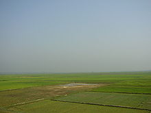
Hakaluki Haor


Hakaluki Haor (Bengali: হাকালুকি হাওর)is a marsh wetland ecosystem of north-eastern Bangladesh.[1] It is one of Bangladesh's largest and one of Asia's large marsh wetland resources. Hakaluki Haor is bounded by the Kushiara river as well as a part of the Sonai Bardal river to the north, by the Fenchuganj-Kulaura railway to the west and to the south, and by the Kulaura-Beanibazar road the east. It lies between 24°35’ N to 24°44’ N and 92°00’ E to 92°08’ E.[2]
A total of 558 species of animals and birds have been identified here, including some very rare – already declared as threatened, vulnerable, endangered and critically endangered species. Some 190,000 people live in the surrounding Hakaluki haor area.[3]
Hakaluki Haor was designated an Ecologically Critical Area (ECA).
The surface area of Hakaluki Haor is 181.15 km2, of which 72.46 km2 (40.01%) is within the territory of Barlekha Upazila. It is also under Kulaura Juri upazila of Moulvibazar District and Golapganj, Fenchuganj upazila of Sylhet district.[1]
See also
[edit]References
[edit]- ^ a b Nixon Talukder and Sanzida Murshed (2012). "Hakaluki Haor". In Sirajul Islam; Miah, Sajahan; Khanam, Mahfuza; Ahmed, Sabbir (eds.). Banglapedia: the National Encyclopedia of Bangladesh (Online ed.). Dhaka, Bangladesh: Banglapedia Trust, Asiatic Society of Bangladesh. ISBN 984-32-0576-6. OCLC 52727562. OL 30677644M. Retrieved 18 November 2024.
- ^ Choudhury, G. A., Nishat, A. Hydro-meteorological characteristics of Hakaluki Haor. IUCN Bangladesh Country Office. Dhaka. 2005. ISBN 984-8574-23-9 "[1]"
- ^ "Ecologically Critical Area", M. Aminul Islam, Banglapedia
