Cuchilla de Haedo
Appearance
(Redirected from Haedo Range)

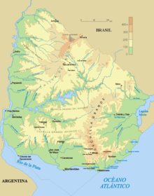
The Cuchilla de Haedo (Haedo Range) is a low range of hills located in the north-northwest of Uruguay, to the west of Tacuarembó,[1] and running southwest toward Paysandú.[2] It climbs no more than 500 m in height.[1] This ridge is separated from the Cuchilla Grande to the south by the Río Negro valley.[3]
See also
[edit]References
[edit]- ^ a b Bao, Sandra; et al. (2010), Argentina, Country Guide Series (7th ed.), Lonely Planet, p. 538, ISBN 1741794641.
- ^ Reclus, Elisée (1895), Keane, Augustus Henry (ed.), The Earth and Its Inhabitants, Africa: North-west Africa, vol. 2, D. Appleton.
- ^ Blouet, Brian W.; Blouet, Olwyn M. (2009), Latin America and the Caribbean: A Systematic and Regional Survey (6th ed.), John Wiley & Sons, ISBN 0470387734.
31°40′42″S 56°16′01″W / 31.67833°S 56.26694°W
