Grenadines Parish
Appearance
(Redirected from Grenadines Parish, Saint Vincent and the Grenadines)
Grenadines | |
|---|---|
Parish | |
 | |
| Coordinates: 13°01′N 061°14′W / 13.017°N 61.233°W | |
| Country | Saint Vincent and the Grenadines |
| Capital City | Port Elizabeth |
| Area | |
• Total | 17 sq mi (44 km2) |
| Elevation | 999 ft (304 m) |
| Population | |
• Total | 9,200 |
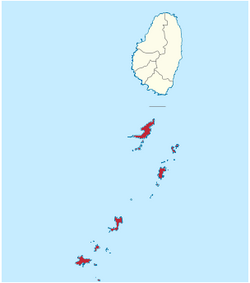
Grenadines is an administrative parish of Saint Vincent and the Grenadines, comprising the islands of the Grenadines other than those belonging to Grenada. The capital is Port Elizabeth. It's the only parish in the country that's not located on the main island.
- Area: 44 km² (17 mi²)
- Population: 9,200 (2000 estimates)
Islands
[edit]The parish includes the northern Grenadine Islands:[1]
- All Awash Island (12°55′N 061°08′W / 12.917°N 61.133°W)
- Baliceaux (Baliceaux Island, 12°57′N 061°08′W / 12.950°N 61.133°W)
- Battowia (Battowia Island, 12°58′N 061°08′W / 12.967°N 61.133°W)
- Bequia (13°01′N 061°13′W / 13.017°N 61.217°W)
- Canouan (Canouan Island, 12°43′N 061°20′W / 12.717°N 61.333°W)
- Catholic Island (12°40′N 061°24′W / 12.667°N 61.400°W)
- Church Cay (12°57′N 061°08′W / 12.950°N 61.133°W)
- Dove Cay (12°41′N 061°21′W / 12.683°N 61.350°W)
- L'Islot (12°41′N 061°21′W / 12.683°N 61.350°W)
- Mayreau (12°39′N 061°23′W / 12.650°N 61.383°W)
- Mustique (12°53′N 061°11′W / 12.883°N 61.183°W)
- Petit Canouan (12°47′N 061°17′W / 12.783°N 61.283°W)
- Petit Cay (12°50′N 061°12′W / 12.833°N 61.200°W)
- Petit Mustique (12°51′N 061°12′W / 12.850°N 61.200°W)
- Petit Nevis (12°58′N 061°15′W / 12.967°N 61.250°W)
- Petit Saint Vincent (12°32′N 061°23′W / 12.533°N 61.383°W)
- Pigeon Island (12°57′N 061°17′W / 12.950°N 61.283°W)
- Prune Island (Palm Island, 12°35′N 061°24′W / 12.583°N 61.400°W)
- Quatre (Isle à Quatre, 12°57′N 061°15′W / 12.950°N 61.250°W)
- Rabbit Island (12°51′N 061°10′W / 12.850°N 61.167°W)
- Red Island (12°36′N 061°25′W / 12.600°N 61.417°W)
- Saint Elairs Cay (12°59′N 061°14′W / 12.983°N 61.233°W)
- Sand Cay (12°36′N 061°26′W / 12.600°N 61.433°W)
- Savan (Savan Island, 12°48′N 061°12′W / 12.800°N 61.200°W)
- The Pillories (Les Piloris, 12°54′N 061°10′W / 12.900°N 61.167°W)
- Tobago Cays (12°38′N 061°21′W / 12.633°N 61.350°W)
- Union Island (12°36′N 061°26′W / 12.600°N 61.433°W)
Populated places
[edit]The following populated places are located in the parish of Grenadine:[1]
References
[edit]- ^ a b "GeoNames Search". National Geospatial-Intelligence Agency. Retrieved 2 March 2013.
- ^ "Ashton". Wikimapia. Retrieved 3 March 2013.
- ^ "Charlestown". Wikimapia. Retrieved 3 March 2013.
- ^ "Clifton". Wikimapia. Retrieved 3 March 2013.
- ^ "Friendship". Wikimapia. Retrieved 3 March 2013.
- ^ "Lovell Village". Wikimapia. Retrieved 3 March 2013.
- ^ "Old Wall". Wikimapia. Retrieved 3 March 2013.
- ^ "Lovell Village". Wikimapia. Retrieved 3 March 2013.
- ^ "Port Elizabeth". Wikimapia. Retrieved 3 March 2013.
This article needs additional citations for verification. (March 2013) |
External links
[edit]- Parishes of Saint Vincent and the Grenadines, Statoids.com
