Davenport–Moline–Clinton, Muscatine, Iowa–Illinois Combined Statistical Area
Greater Quad Cities CSA | |
|---|---|
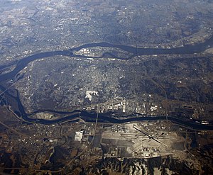
 Aerial view of the Quad Cities | |
 | |
| Country | |
| State | |
| Largest city | Davenport, Iowa |
| Other cities | Moline, Illinois Bettendorf, Iowa Rock Island, Illinois East Moline, Illinois |
| Area | |
• Total | 170 sq mi (400 km2) |
| Highest elevation | 850 ft (259 m) |
| Lowest elevation | 590 ft (180 m) |
| Population | |
• Total | 379,374 (147th) |
| • Rank | 147th in the U.S. |
| • Density | 1,600/sq mi (618/km2) |
| Time zone | UTC-06:00 (CST) |
| • Summer (DST) | UTC-05:00 (CDT) |
Greater Quad Cities, IA–IL is a nickname for the Davenport–Moline, IA–IL Combined Statistical Area,[1] an area that is made up of four counties in Iowa and three in Illinois. The statistical area includes one metropolitan areas and two micropolitan area. As of the 2010 Census, the CSA had a population of 471,551 (though a March 2017 estimate placed the population at 472,153).[2]
The area consists of the:
- Quad Cities Metropolitan Area, population 383,681.
- Clinton, IA Micropolitan Statistical Area, population 48,420.
- Muscatine, Iowa micropolitan area, population 54,118.
Counties
[edit]In Iowa
[edit]- Scott County pop. 170,385
- Clinton County pop. 48,420
- Muscatine County pop. 42,836
- Louisa County pop. 11,282
In Illinois
[edit]- Rock Island County pop. 147,258
- Henry County pop. 49,860
- Mercer County pop. 16,178
Communities
[edit]The communities (both incorporated and unincorporated) in the combined statistical area are as follows:
- In Iowa
- Davenport
- Andover
- Bettendorf
- Blue Grass
- Bryant
- Buffalo
- Calamus
- Camanche
- Charlotte
- Clinton
- Columbus City
- Columbus Junction
- Cotter
- Cranston
- Creekville
- Delmar
- DeWitt
- Dixon
- Donahue
- Eldridge
- Elvira
- Elwood
- Fairport
- Fredonia
- Goose Lake
- Grand Mound
- Grandview
- Le Claire
- Letts
- Long Grove
- Lost Nation
- Low Moor
- Maysville
- McCausland
- Midway Beach
- Montpelier
- Morning Sun
- Moscow
- Mount Joy
- Muscatine
- New Liberty
- Oakville
- Panorama Park
- Park View
- Petersburg
- Princeton
- Riverdale
- Teeds Grove
- Toolesboro
- Toronto
- Walcott
- Wapello
- Welton
- West Liberty
- Wheatland
- Wilton
- In Illinois
Education institutes
[edit]Higher education
[edit]Eastern Iowa Community Colleges
Primary and secondary education
[edit]Transportation
[edit]Airports
[edit]Below is a list of the airports in the greater area, followed by their number of enplanements (commercial passenger boardings) that occurred at the airport in calendar year 2013.
Public
[edit]- Quad City International Airport (IATA: MLI, ICAO: KMLI, FAA LID: MLI), 49,170
- Davenport Municipal Airport (IATA: DVN, ICAO: KDVN, FAA LID: DVN), 28,251
- Muscatine Municipal Airport (IATA: MUT, ICAO: KMUT, FAA LID: MUT), 14,106
- Clinton Municipal Airport (IATA: CWI, ICAO: KCWI, FAA LID: CWI), 14,106
Transit
[edit]- Bettendorf Transit
- Clinton Municipal Transit Administration
- Davenport Citibus
- MuscaBus
- Quad Cities MetroLINK
- River Bend Transit
- List of intercity bus stops in Illinois
- List of intercity bus stops in Iowa
Interstates
[edit]Principal Highways
[edit]State Highways
[edit] Iowa State Route 22
 Iowa State Route 38
 Iowa State Route 70
 Iowa State Route 78
 Iowa State Route 92
 Iowa State Route 130
 Iowa State Route 136
 Illinois State Route 5
 Illinois State Route 17
 Illinois State Route 78
 Illinois State Route 81
 Illinois State Route 82
 Illinois State Route 84
 Illinois State Route 92
 Illinois State Route 93
 Illinois State Route 94
 Illinois State Route 192
Shopping
[edit]Below are some notable shopping centers in the area:
- NorthPark Mall (Davenport, IA)
- SouthPark Mall (Moline, IL)
- Muscatine Mall (Muscatine, IA)
References
[edit]- ^ "OMB Bulletin No. 17-01: Revised Delineations of Metropolitan Statistical Areas, Micropolitan Statistical Areas, and Combined Statistical Areas, and Guidance on Uses of the Delineations of These Areas" (PDF). United States Office of Management and Budget. August 15, 2017. Archived from the original (PDF) on January 21, 2019. Retrieved March 6, 2018.
- ^ "Annual Estimates of the Resident Population: April 1, 2010 to July 1, 2017 - United States -- Combined Statistical Area; and for Puerto Rico". United States Census Bureau, Population Division. March 2018. Retrieved March 31, 2018.[permanent dead link]


