Grímsnes- og Grafningshreppur
Appearance
Grímsnes- og Grafningshreppur | |
|---|---|
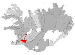
 Location of Grímsnes- og Grafningshreppur | |
| Country | Iceland |
| Region | Southern Region |
| Constituency | South Constituency |
| Government | |
| • Manager | Ingibjörg Harðardóttir |
| Area | |
• Total | 900 km2 (300 sq mi) |
| Population | |
• Total | 422 |
| • Density | 0.47/km2 (1.2/sq mi) |
| Municipal number | 8719 |
| Website | gogg |
Grímsnes- og Grafningshreppur (Icelandic pronunciation: [ˈkrimsˌnɛːs ɔːɣ ˈkrapniŋsˌr̥ɛhpʏr̥] ) is a municipality in the south-western part of Iceland, in the Southern Region. It was formed in 1998 by the merger of Grímsneshreppur and Grafningshreppur. The main settlement is Sólheimar with 80 inhabitants (2006). The settlement Írafoss og Ljósafoss [ˈiːraˌfɔsː ɔːɣ ˈljouːsaˌfɔsː], which still had 15 inhabitants in 1997, has been abandoned since then.
References
[edit]External links
[edit]![]() Media related to Grímsnes- og Grafningshreppur at Wikimedia Commons
Media related to Grímsnes- og Grafningshreppur at Wikimedia Commons
64°04′07″N 20°38′35″W / 64.06861°N 20.64306°W
