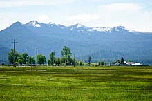
Fort Klamath, Oregon
Appearance
(Redirected from Fort Klamath, OR)

Fort Klamath is an unincorporated community between Crater Lake National Park and Upper Klamath Lake in Klamath County, Oregon, United States.
The community is located about a mile northwest of Fort Klamath, the Oregon Trail military outpost. Fort Klamath post office was established January 6, 1879.[1]
Climate
[edit]This region experiences warm (but not hot) and dry summers, with no average monthly temperatures above 71.6 °F. According to the Köppen Climate Classification system, Fort Klamath has a warm-summer Mediterranean climate, abbreviated "Csb" on climate maps.[2]
| Climate data for Fort Klamath, OR | |||||||||||||
|---|---|---|---|---|---|---|---|---|---|---|---|---|---|
| Month | Jan | Feb | Mar | Apr | May | Jun | Jul | Aug | Sep | Oct | Nov | Dec | Year |
| Record high °F (°C) | 64 (18) |
65 (18) |
72 (22) |
84 (29) |
93 (34) |
104 (40) |
103 (39) |
104 (40) |
100 (38) |
92 (33) |
72 (22) |
57 (14) |
104 (40) |
| Mean maximum °F (°C) | 50 (10) |
55 (13) |
64 (18) |
75 (24) |
83 (28) |
89 (32) |
94 (34) |
94 (34) |
89 (32) |
80 (27) |
63 (17) |
50 (10) |
96 (36) |
| Mean daily maximum °F (°C) | 39.2 (4.0) |
44.1 (6.7) |
50.4 (10.2) |
56.9 (13.8) |
66.4 (19.1) |
75.0 (23.9) |
84.9 (29.4) |
84.3 (29.1) |
77.5 (25.3) |
63.9 (17.7) |
47.9 (8.8) |
38.9 (3.8) |
60.8 (16.0) |
| Daily mean °F (°C) | 28.9 (−1.7) |
32.9 (0.5) |
37.6 (3.1) |
42.7 (5.9) |
49.8 (9.9) |
56.2 (13.4) |
63.5 (17.5) |
62.4 (16.9) |
55.9 (13.3) |
45.7 (7.6) |
35.9 (2.2) |
28.9 (−1.7) |
45.0 (7.2) |
| Mean daily minimum °F (°C) | 18.6 (−7.4) |
21.6 (−5.8) |
24.8 (−4.0) |
28.4 (−2.0) |
33.2 (0.7) |
37.4 (3.0) |
42.1 (5.6) |
40.6 (4.8) |
34.2 (1.2) |
27.5 (−2.5) |
23.8 (−4.6) |
18.9 (−7.3) |
29.3 (−1.5) |
| Mean minimum °F (°C) | 1 (−17) |
5 (−15) |
12 (−11) |
18 (−8) |
22 (−6) |
27 (−3) |
33 (1) |
33 (1) |
26 (−3) |
18 (−8) |
9 (−13) |
0 (−18) |
−5 (−21) |
| Record low °F (°C) | −25 (−32) |
−19 (−28) |
−12 (−24) |
6 (−14) |
13 (−11) |
20 (−7) |
24 (−4) |
26 (−3) |
17 (−8) |
7 (−14) |
−7 (−22) |
−20 (−29) |
−25 (−32) |
| Average precipitation inches (mm) | 3.78 (96) |
2.25 (57) |
1.94 (49) |
1.42 (36) |
1.49 (38) |
0.61 (15) |
0.24 (6.1) |
0.31 (7.9) |
0.46 (12) |
1.37 (35) |
2.84 (72) |
4.36 (111) |
21.07 (535) |
| Average snowfall inches (cm) | 14.6 (37) |
10.3 (26) |
7.6 (19) |
2.5 (6.4) |
0.3 (0.76) |
0.0 (0.0) |
0.0 (0.0) |
0.0 (0.0) |
0.0 (0.0) |
0.9 (2.3) |
7.9 (20) |
18.6 (47) |
62.7 (158.46) |
| Average precipitation days (≥ 0.01 in) | 12.8 | 10.5 | 10.9 | 9.8 | 7.9 | 4.2 | 2.1 | 2.6 | 3.4 | 7.5 | 12.1 | 13.8 | 97.6 |
| Average snowy days (≥ 0.1 in) | 6.5 | 4.9 | 4.1 | 1.7 | 0.4 | 0.0 | 0.0 | 0.0 | 0.0 | 0.1 | 2.3 | 7.6 | 27.6 |
| Source: NOAA[3] | |||||||||||||
References
[edit]- ^ McArthur, Lewis A.; Lewis L. McArthur (2003) [1928]. Oregon Geographic Names (Seventh ed.). Portland, Oregon: Oregon Historical Society Press. ISBN 0-87595-277-1.
- ^ Climate Summary for Fort Klamath, Oregon
- ^ "U.S. Climate Normals Quick Access – Station: Fort Klamath". National Oceanic and Atmospheric Administration. Retrieved November 10, 2023.
External links
[edit]- Photos of Fort Klamath on Flickr, by Jasperdo
42°42′17″N 121°59′41″W / 42.70472°N 121.99472°W

