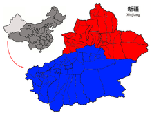
File:Xinjiang regions.png
Appearance

Size of this preview: 789 × 600 pixels. Other resolutions: 316 × 240 pixels | 631 × 480 pixels | 960 × 730 pixels.
Original file (960 × 730 pixels, file size: 100 KB, MIME type: image/png)
File history
Click on a date/time to view the file as it appeared at that time.
| Date/Time | Thumbnail | Dimensions | User | Comment | |
|---|---|---|---|---|---|
| current | 01:13, 8 November 2011 |  | 960 × 730 (100 KB) | Quigley |
File usage
The following 10 pages use this file:
- Dzungar conquest of Altishahr
- List of khans of the Yarkent and Turpan khanates
- Mamenchisaurus
- Southern Xinjiang
- Tarim Basin
- Xinjiang under Qing rule
- Talk:History of Xinjiang/Archive 1
- Talk:History of the administrative divisions of China before 1912
- User:Hidayetullah/sandbox
- Wikipedia:Graphics Lab/Map workshop/Archive/Jun 2014
Global file usage
The following other wikis use this file:
- Usage on ast.wikipedia.org
- Usage on bn.wikipedia.org
- Usage on de.wikipedia.org
- Usage on es.wikipedia.org
- Usage on fr.wikipedia.org
- Usage on gl.wikipedia.org
- Usage on id.wikipedia.org
- Usage on ja.wikipedia.org
- Usage on lv.wikipedia.org
- Usage on mk.wikipedia.org
- Usage on nl.wikipedia.org
- Usage on pt.wikipedia.org
- Usage on sat.wikipedia.org
- Usage on ta.wikipedia.org
- Usage on tr.wikipedia.org
- Usage on uz.wikipedia.org
- Usage on zh.wikipedia.org


