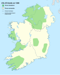
File:Www.wesleyjohnston.com-users-ireland-maps-historical-map1300.gif
Appearance
Www.wesleyjohnston.com-users-ireland-maps-historical-map1300.gif (466 × 582 pixels, file size: 9 KB, MIME type: image/gif)
File history
Click on a date/time to view the file as it appeared at that time.
| Date/Time | Thumbnail | Dimensions | User | Comment | |
|---|---|---|---|---|---|
| current | 18:51, 29 August 2009 |  | 466 × 582 (9 KB) | The Illusional Ministry | Fixed borders and colours. |
| 08:09, 1 August 2007 |  | 466 × 582 (11 KB) | Papa November | {{Information |Description=Historical map of Ireland from http://Www.wesleyjohnston.com/users/ireland/maps/historical/map1300.gif |Source=Originally from [http://en.wikipedia.org en.wikipedia]; description page is/was [http://en.wikipedia.org/w/index.php? |
File usage
The following 9 pages use this file:
Global file usage
The following other wikis use this file:
- Usage on ar.wikipedia.org
- Usage on ca.wikipedia.org
- Usage on fa.wikipedia.org
- Usage on fi.wikipedia.org
- Usage on fr.wikipedia.org
- Usage on ga.wikipedia.org
- Usage on he.wikipedia.org
- Usage on hr.wikipedia.org
- Usage on hu.wikipedia.org
- Usage on it.wikipedia.org
- Usage on ja.wikipedia.org
- Usage on kab.wikipedia.org
- Usage on ko.wikipedia.org
- Usage on ru.wikipedia.org
- Usage on sh.wikipedia.org
- Usage on sl.wikipedia.org
- Usage on tr.wikipedia.org
- Usage on tum.wikipedia.org
- Galway, Ireland
- Leitrim, Ireland
- Mayo, Ireland
- Roscommon, Ireland
- Sligo, Ireland
- Carlow, Ireland
- Dublin, Ireland
- Dún Laoghaire–Rathdown, Ireland
- Fingal, Ireland
- South Dublin, Ireland
- Kildare, Ireland
- Kilkenny, Ireland
- Laois, Ireland
- Longford, Ireland
- Louth, Ireland
- Meath, Ireland
- County Offaly
- Westmeath, Ireland
- Wexford, Ireland
- Wicklow, Ireland
View more global usage of this file.


