File:World population pie chart.JPG
Appearance

Size of this preview: 800 × 533 pixels. Other resolutions: 320 × 213 pixels | 640 × 427 pixels.
Original file (900 × 600 pixels, file size: 81 KB, MIME type: image/jpeg)
File history
Click on a date/time to view the file as it appeared at that time.
| Date/Time | Thumbnail | Dimensions | User | Comment | |
|---|---|---|---|---|---|
| current | 03:19, 12 May 2008 |  | 900 × 600 (81 KB) | Brutannica~commonswiki | removing pointless Other North America, New Zealand boxes |
| 03:18, 12 May 2008 |  | 900 × 600 (81 KB) | Brutannica~commonswiki | ||
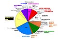
| 02:20, 10 April 2008 |  | 900 × 600 (85 KB) | Brutannica~commonswiki | Global population distribution by region. Colours indicate broad regions while smaller divisions within these colours indicate subregions. "Other North America" refers to Greenland and St. Pierre & Miquelon. The division between Western and Eastern Europe | |
| 23:09, 2 April 2008 |  | 900 × 780 (88 KB) | Brutannica~commonswiki | {{Information |Description=Global population distribution by region. Colours indicate broad regions while smaller divisions within these colours indicate subregions. |Source=self-made |Date=March 2008 |Author= Brutannica |Permission= | |
File usage
The following page uses this file:
Global file usage
The following other wikis use this file:
- Usage on es.wikipedia.org


