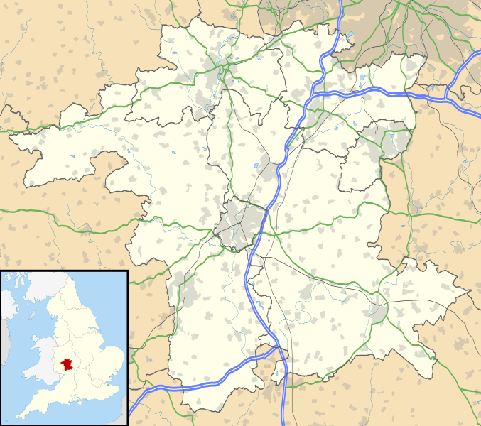
File:Worcestershire UK location map.svg
Appearance

Size of this PNG preview of this SVG file: 677 × 600 pixels. Other resolutions: 271 × 240 pixels | 542 × 480 pixels | 867 × 768 pixels | 1,156 × 1,024 pixels | 2,313 × 2,048 pixels | 1,425 × 1,262 pixels.
Original file (SVG file, nominally 1,425 × 1,262 pixels, file size: 1.8 MB)
File history
Click on a date/time to view the file as it appeared at that time.
| Date/Time | Thumbnail | Dimensions | User | Comment | |
|---|---|---|---|---|---|
| current | 19:20, 26 September 2010 |  | 1,425 × 1,262 (1.8 MB) | Nilfanion | {{Information |Description=Map of Worcestershire, UK with the following information shown: *Administrative borders *Coastline, lakes and rivers *Roads and railways *Urban areas Equirectangular map projection on WGS 84 datum, with N/S |
File usage
More than 100 pages use this file. The following list shows the first 100 pages that use this file only. A full list is available.
- Ab Lench
- Abberley
- Abberton, Worcestershire
- Abbots Morton
- Aldington, Worcestershire
- Alfrick
- Alvechurch
- Areley Kings
- Ashton under Hill
- Aston Somerville
- Badsey
- Barnards Green
- Barnt Green
- Battle of Worcester
- Bayton
- Beckford, Worcestershire
- Belbroughton
- Beoley
- Berrow, Worcestershire
- Besford
- Bewdley
- Bickmarsh
- Birlingham
- Birtsmorton
- Bishampton
- Blakedown
- Bockleton
- Bordesley, Worcestershire
- Bournheath
- Bredon
- Broadwas
- Broadway, Worcestershire
- Bromsgrove
- Broome, Worcestershire
- Broughton Hackett
- Catshill
- Chaddesley Corbett
- Cofton Hackett
- Droitwich Spa
- Droitwich Transmitting Station
- Eckington, Worcestershire
- Evesham
- Feckenham
- Fladbury
- Great Malvern
- Great Witley
- Guarlford
- Hanbury, Worcestershire
- Hartlebury
- Heightington
- Hollywood, Worcestershire
- Holt Heath, Worcestershire
- Hopwood, Worcestershire
- Hopwood Park services
- Kempsey, Worcestershire
- Kidderminster
- Leigh, Worcestershire
- Lickey
- Lickey End
- Lindridge
- List of places in Worcestershire
- Little Malvern
- Lower Broadheath
- Lydiate Ash
- Madresfield
- Malvern, Worcestershire
- Malvern Link
- Malvern Wells
- Mamble
- Martin Hussingtree
- Martley
- Norton, Worcestershire
- Pendock
- Pensham
- Pershore
- Pinvin
- Pirton, Worcestershire
- Powick
- Queenhill
- Rock, Worcestershire
- Romsley, Worcestershire
- Ryall, Worcestershire
- Shelsley Walsh
- St Peter the Great County, Worcestershire
- Stockton on Teme
- Stoke Heath, Worcestershire
- Stourport-on-Severn
- Tardebigge
- Tenbury Wells
- The Fleece Inn
- Throckmorton, Worcestershire
- Upper Arley
- Upton-upon-Severn
- Wadborough
- Warndon
- West Malvern
- White Ladies Aston
- Whittington, Worcestershire
- Worcester Cathedral
- Wychbold
View more links to this file.
Global file usage
The following other wikis use this file:
- Usage on ar.wikipedia.org
- Usage on bg.wikipedia.org
- Usage on ceb.wikipedia.org
- Usage on es.wikipedia.org
- Worcester
- Evesham
- Plantilla:Mapa de localización de Worcestershire
- Far Forest
- Childswickham
- Clifton upon Teme
- Badsey
- Barnt Green
- Ashton under Hill
- Cookley
- Cropthorne
- Crowle (Worcestershire)
- Belbroughton
- Defford
- Alvechurch
- Bewdley
- Drakes Broughton
- Blackwell
- Blakedown
- Bredon
- Bretforton
- Broadway (Worcestershire)
- Callow End
- Lower Broadheath
- Fernhill Heath
- Fladbury
- Hallow
- Eckington (Worcestershire)
- Elmley Castle
- Great Malvern
- Great Witley
- Hanley Swan
- Harvington
- Holy Cross
- Honeybourne
- Hopwood (Worcestershire)
- Inkberrow
- Lower Moor
- Norton (Worcestershire)
- Kempsey
- Major's Green
- Leigh Sinton
- Long Lartin Prison
- North Littleton
- Callow Hill
- Catshill
View more global usage of this file.
