Jump to content

File:Williamsburgcapitol.jpg

Page contents not supported in other languages.
This is a file from the Wikimedia Commons
From Wikipedia, the free encyclopedia

Original file (1,536 × 1,175 pixels, file size: 1.28 MB, MIME type: image/jpeg)

Summary

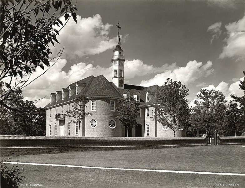
Description
English: Collection: A. D. White Architectural Photographs, Cornell University Library

Accession Number: 15/5/3090.00549

Title: The Capitol, Colonial Williamsburg

Photographer: Fay Sturtevant Lincoln (American, 1894-1975) Architect: Henry Cary (c. 1680-1749)

Building Date: 1703-1705 Photograph date: ca. 1934-ca. 1950

Location: North and Central America: United States; Virginia, Williamsburg

Materials: gelatin silver print

Image: 7 3/8 x 9 3/8 in.; 18.7325 x 23.8125 cm

Style: American Colonial

Provenance: Transfer from the College of Architecture, Art and Planning

Persistent URI: http://library24.library.cornell.edu/collections/adw/75706-10040169.html

There are no known U.S. copyright restrictions on this image. The digital file is owned by the Cornell University Library which is making it freely available with the request that, when possible, the Library be credited as its source.

This is an image of a place or building that is listed on the National Register of Historic Places in the United States of America. Its reference number is 66000925.

Date between circa 1934 and circa 1950
date QS:P,+1950-00-00T00:00:00Z/7,P1319,+1934-00-00T00:00:00Z/9,P1326,+1950-00-00T00:00:00Z/9,P1480,Q5727902
Source https://www.flickr.com/photos/cornelluniversitylibrary/3678095551/in/set-72157620818011784/
Author
Fay Sturtevant Lincoln  (1894–1975)  wikidata:Q92763752
 
Alternative names
F. S. Lincoln; Fay S. Lincoln
Description American photographer
Date of birth/death 16 February 1894 Edit this at Wikidata December 1975 Edit this at Wikidata
Location of birth/death Keene Edit this at Wikidata Centre Hall Edit this at Wikidata
Work period 1929 Edit this at Wikidata–1965 Edit this at Wikidata
Work location
Authority file
creator QS:P170,Q92763752
Object location37° 15′ 45″ N, 76° 41′ 59″ W Kartographer map based on OpenStreetMap.View this and other nearby images on: OpenStreetMapinfo

Licensing

w:en:Creative Commons
attribution
This file is licensed under the Creative Commons Attribution 2.0 Generic license.
You are free:
  • to share – to copy, distribute and transmit the work
  • to remix – to adapt the work
Under the following conditions:
  • attribution – You must give appropriate credit, provide a link to the license, and indicate if changes were made. You may do so in any reasonable manner, but not in any way that suggests the licensor endorses you or your use.
This image was originally posted to Flickr by Cornell University Library at https://www.flickr.com/photos/30515687@N05/3678095551. It was reviewed on 13 August 2009 by FlickreviewR and was confirmed to be licensed under the terms of the cc-by-2.0.

13 August 2009

Captions

Add a one-line explanation of what this file represents

Items portrayed in this file

depicts

37°15'45.0"N, 76°41'58.9"W

File history

Click on a date/time to view the file as it appeared at that time.

Date/TimeThumbnailDimensionsUserComment
current18:20, 13 August 2009Thumbnail for version as of 18:20, 13 August 20091,536 × 1,175 (1.28 MB)FlickreviewRReplacing image by its original image from Flickr
17:16, 13 August 2009Thumbnail for version as of 17:16, 13 August 20091,024 × 783 (494 KB)Jpc4031{{Information |Description={{en|1=Collection: A. D. White Architectural Photographs, Cornell University Library Accession Number: 15/5/3090.00549 Title: The Capitol, Colonial Williamsburg Photographer: Fay Sturtevant Lincoln (American, 1894-1975) Archit

Global file usage

The following other wikis use this file:

Metadata