Jump to content

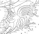
File:Whewell tidal chart Britain and Ireland 1836.jpg

Page contents not supported in other languages.
This is a file from the Wikimedia Commons
From Wikipedia, the free encyclopedia

Original file (7,610 × 6,704 pixels, file size: 4.4 MB, MIME type: image/jpeg)

Summary

Description
English: Chart of the coasts of Britain Ireland and the North Sea showing cotidal lines. Plate 24 p307 from Whewell, William (1836). "On the results of an extensive system of tide observations made on the coasts of Europe and America in June 1835". Philosophical Transactions 126: 289-341.
Date
Source https://archive.org/details/jstor-108036
Author William Whewell
Other versions

Licensing

Public domain

This work is in the public domain in its country of origin and other countries and areas where the copyright term is the author's life plus 70 years or fewer.


This work is in the public domain in the United States because it was published (or registered with the U.S. Copyright Office) before January 1, 1929.

This file has been identified as being free of known restrictions under copyright law, including all related and neighboring rights.

Captions

Chart of the coasts of Britain Ireland and the North Sea showing cotidal lines

Items portrayed in this file

depicts

16 June 1936

image/jpeg

File history

Click on a date/time to view the file as it appeared at that time.

Date/TimeThumbnailDimensionsUserComment
current14:04, 3 November 2019Thumbnail for version as of 14:04, 3 November 20197,610 × 6,704 (4.4 MB)KognosUser created page with UploadWizard
No pages on the English Wikipedia use this file (pages on other projects are not listed).

Global file usage

The following other wikis use this file: