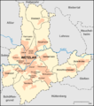
File:Wetzlar Stadtteile Karte.png
Appearance

Size of this preview: 530 × 600 pixels. Other resolutions: 212 × 240 pixels | 424 × 480 pixels | 884 × 1,000 pixels.
Original file (884 × 1,000 pixels, file size: 234 KB, MIME type: image/png)
File history
Click on a date/time to view the file as it appeared at that time.
| Date/Time | Thumbnail | Dimensions | User | Comment | |
|---|---|---|---|---|---|
| current | 18:08, 7 May 2008 |  | 884 × 1,000 (234 KB) | Lencer | |
| 17:47, 7 May 2008 |  | 884 × 1,000 (234 KB) | Lencer | + Maßstabsleiste | |
| 16:07, 5 May 2008 |  | 884 × 1,000 (233 KB) | Lencer | ||
| 15:35, 5 May 2008 |  | 884 × 1,000 (236 KB) | Lencer | {{Information |Description= Karte der Stadtteile, Stadtbezirke und Umlandgemeinden Wetzlars |Source="own work", used: * http://www.wetzlar.de/showobject.phtml?La=1&object=med|370.4577.1.g |Date=Mai 2008 |Author=Lencer |
File usage
The following page uses this file:
Global file usage
The following other wikis use this file:
- Usage on azb.wikipedia.org
- Usage on da.wikipedia.org
- Usage on de.wikipedia.org
- Usage on fi.wikipedia.org
- Usage on fy.wikipedia.org
- Usage on hu.wikipedia.org
- Usage on ja.wikipedia.org
- Usage on nl.wikipedia.org

