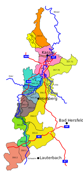
File:Westhessische senke.svg
Appearance

Size of this PNG preview of this SVG file: 272 × 599 pixels. Other resolutions: 109 × 240 pixels | 218 × 480 pixels | 348 × 768 pixels | 465 × 1,024 pixels | 929 × 2,048 pixels | 414 × 912 pixels.
Original file (SVG file, nominally 414 × 912 pixels, file size: 126 KB)
File history
Click on a date/time to view the file as it appeared at that time.
| Date/Time | Thumbnail | Dimensions | User | Comment | |
|---|---|---|---|---|---|
| current | 18:12, 1 June 2009 |  | 414 × 912 (126 KB) | Markus Schulenburg | Darstellungsprobleme hoffentlich beseitigt |
| 12:07, 1 June 2009 |  | 414 × 912 (127 KB) | Markus Schulenburg | Fehler beseitigt | |
| 12:00, 1 June 2009 |  | 414 × 912 (125 KB) | Markus Schulenburg | Angrenzende Untereinheiten des Naturraumes 35 eingezeichnet | |
| 13:22, 24 November 2008 |  | 414 × 912 (94 KB) | Markus Schulenburg | {{Information |Description= |Source= |Date= |Author= |Permission= |other_versions= }} | |
| 13:12, 24 November 2008 |  | 414 × 912 (96 KB) | Markus Schulenburg | {{Information |Description={{en|1=Map of macrochore "westhessian dip" a geological entity in Hesse, Germany}} {{de|1=Karte der "westhessischen Senke" ein Naturraum in Hessen, Deutschland}} |Source=Eigenes Werk (own work) |Author=[[User:Markus Schulenburg| |
File usage
The following 2 pages use this file:
Global file usage
The following other wikis use this file:
- Usage on bg.wikipedia.org
- Usage on de.wikipedia.org
- Usage on es.wikipedia.org
- Usage on fr.wikipedia.org
- Usage on www.wikidata.org


