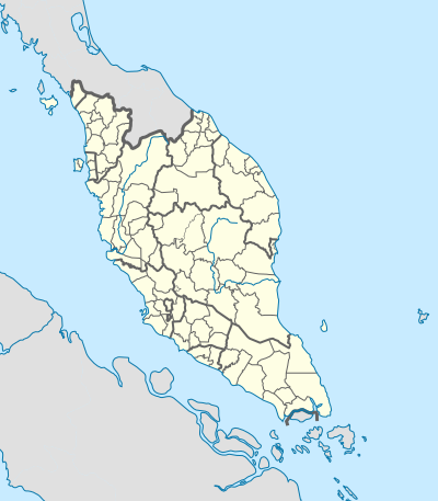
File:West Malaysia location map with districts.svg
Appearance

Size of this PNG preview of this SVG file: 400 × 457 pixels. Other resolutions: 210 × 240 pixels | 420 × 480 pixels | 672 × 768 pixels | 896 × 1,024 pixels | 1,792 × 2,048 pixels.
Original file (SVG file, nominally 400 × 457 pixels, file size: 998 KB)
File history
Click on a date/time to view the file as it appeared at that time.
| Date/Time | Thumbnail | Dimensions | User | Comment | |
|---|---|---|---|---|---|
| current | 10:01, 18 October 2023 |  | 400 × 457 (998 KB) | Zh9567 | add Genting sub-district, Gebeng sub-district, Jelai sub-district: https://mygos.mygeoportal.gov.my/upi/ |
| 15:19, 29 August 2021 |  | 400 × 457 (996 KB) | Zh9567 | adjusted Kuala Terengganu / Kuala Nerus border | |
| 09:42, 10 April 2020 |  | 400 × 457 (1,000 KB) | *angys* | UPDATE | |
| 12:41, 17 April 2019 |  | 400 × 457 (2.32 MB) | *angys* | correcting borders | |
| 15:33, 27 December 2017 |  | 400 × 457 (1.76 MB) | Hellerick | Kuala Terengganu borders corrected | |
| 16:19, 25 December 2017 |  | 400 × 457 (1.76 MB) | Hellerick | correcting district borders | |
| 17:31, 22 December 2017 |  | 400 × 457 (1.75 MB) | Hellerick | User created page with UploadWizard |
File usage
The following 14 pages use this file:
- 2002 Eisenhower Trophy
- 2002 Espirito Santo Trophy
- Aur Island
- Linggi River
- List of districts in Malaysia
- Memali Incident
- Pergau Dam
- RMAF Butterworth Air Base
- Siege of Malacca (1641)
- Tuanku Mizan Zainal Abidin Mosque
- User:Zh9567/Schools/Tamil primary schools
- User talk:Hellerick
- Module:Location map/data/Malaysia West
- Module:Location map/data/Malaysia West/doc
Global file usage
The following other wikis use this file:
- Usage on bn.wikipedia.org
- Usage on hi.wikipedia.org
- Usage on ko.wikipedia.org
- Usage on min.wikipedia.org
- Usage on ms.wikipedia.org
- Usage on simple.wikipedia.org
- Usage on si.wikipedia.org
- Usage on th.wikipedia.org
- Usage on zh-yue.wikipedia.org
- Usage on zh.wikipedia.org

