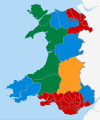
File:Welsh Assembly election 2011 map.svg
Appearance

Size of this PNG preview of this SVG file: 502 × 600 pixels. Other resolutions: 201 × 240 pixels | 402 × 480 pixels | 643 × 768 pixels | 857 × 1,024 pixels | 1,715 × 2,048 pixels | 1,080 × 1,290 pixels.
Original file (SVG file, nominally 1,080 × 1,290 pixels, file size: 174 KB)
File history
Click on a date/time to view the file as it appeared at that time.
| Date/Time | Thumbnail | Dimensions | User | Comment | |
|---|---|---|---|---|---|
| current | 17:15, 25 May 2016 |  | 1,080 × 1,290 (174 KB) | Nilfanion | Please read Commons:Overwriting existing files, derivative map to different locaiton please |
| 15:27, 25 May 2016 |  | 1,662 × 1,176 (195 KB) | Renamed user OCfxJKu7j2 | + LD in Mid and West Wales | |
| 15:22, 25 May 2016 |  | 1,662 × 1,176 (195 KB) | Renamed user OCfxJKu7j2 | Added regions | |
| 16:54, 6 May 2011 |  | 1,080 × 1,290 (174 KB) | Nilfanion | {{Information |Description=Map of the National Assembly for Wales election, 2011, showing constituency results. |Source={{own}} |Date=2011-05-06 |Author= Nilfanion |Permission={{cc-by- |
File usage
The following page uses this file:
Global file usage
The following other wikis use this file:
- Usage on cy.wikipedia.org
