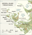
File:Weddell-Island-Map.png
Appearance

Size of this preview: 560 × 600 pixels. Other resolutions: 224 × 240 pixels | 588 × 630 pixels.
Original file (588 × 630 pixels, file size: 245 KB, MIME type: image/png)
File history
Click on a date/time to view the file as it appeared at that time.
| Date/Time | Thumbnail | Dimensions | User | Comment | |
|---|---|---|---|---|---|
| current | 07:45, 23 May 2018 |  | 588 × 630 (245 KB) | Apcbg | details |
| 11:53, 7 May 2018 |  | 588 × 630 (190 KB) | Apcbg | detail | |
| 10:15, 27 April 2018 |  | 588 × 630 (244 KB) | Apcbg | detail | |
| 07:15, 27 April 2018 |  | 588 × 630 (244 KB) | Apcbg | detail | |
| 12:21, 20 April 2018 |  | 588 × 630 (244 KB) | Apcbg | detail | |
| 07:50, 20 April 2018 |  | 588 × 630 (244 KB) | Apcbg | details | |
| 06:44, 20 April 2018 |  | 588 × 630 (244 KB) | Apcbg | detail | |
| 18:21, 18 April 2018 |  | 588 × 630 (190 KB) | Apcbg | colour | |
| 09:46, 19 March 2018 |  | 588 × 630 (243 KB) | Apcbg | detail | |
| 08:39, 19 March 2018 |  | 588 × 630 (242 KB) | Apcbg | details |
File usage
The following 19 pages use this file:
- Chatham Harbour, Weddell Island
- Circum Peak
- French Harbour
- Gull Harbour
- Horse Block
- Hotham Heights
- Loop Head, Weddell Island
- Mount Alice (Falkland Islands)
- Mount Weddell
- New Year Cove
- Pillar Bluff
- Pitt Heights
- Quaker Harbour
- Race Point
- Smylie Channel
- Swan Point, Weddell Island
- Weddell Island
- Weddell Point, Weddell Island
- Weddell Settlement
Global file usage
The following other wikis use this file:
- Usage on de.wikipedia.org
- Usage on fr.wikipedia.org
- Usage on www.wikidata.org
