File:WalesRef1997.png
Appearance

Size of this preview: 533 × 599 pixels. Other resolutions: 213 × 240 pixels | 427 × 480 pixels | 882 × 992 pixels.
Original file (882 × 992 pixels, file size: 83 KB, MIME type: image/png)
File history
Click on a date/time to view the file as it appeared at that time.
| Date/Time | Thumbnail | Dimensions | User | Comment | |
|---|---|---|---|---|---|
| current | 14:51, 5 January 2015 |  | 882 × 992 (83 KB) | Renamed user OCfxJKu7j2 | Reverted to version as of 14:50, 5 January 2015 |
| 14:50, 5 January 2015 |  | 882 × 992 (83 KB) | Renamed user OCfxJKu7j2 | Updated where saturation of colour = strength of vote to make it comparable to other referendums on wikipedia (eg. Quebec/Scottish/Catalan independence, AV Referendum) | |
| 14:50, 5 January 2015 |  | 882 × 992 (83 KB) | Renamed user OCfxJKu7j2 | Updated where saturation of colour = strength of vote to make it comparable to other referendums on wikipedia (eg. Quebec/Scottish/Catalan independence, AV Referendum) | |
| 10:15, 5 March 2011 |  | 882 × 992 (48 KB) | Timrollpickering | More conventional green/yes red/no colour scheme. | |
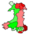
| 03:13, 16 August 2006 |  | 882 × 992 (25 KB) | Hoshie | ==Summary== This is a map of the result of the 1997 referendum on devolution held in Wales on 18 Sept 1997. This map shows all 22 unitary authorities and their result. The map has been made from Morwen's blank [[:en:Image:Wales1996Bla |
File usage
The following page uses this file:
Global file usage
The following other wikis use this file:
- Usage on cy.wikipedia.org
- Usage on id.wikipedia.org
- Usage on pt.wikipedia.org


