
File:WXK92 coverage map.gif

Size of this preview: 463 × 599 pixels. Other resolutions: 185 × 240 pixels | 371 × 480 pixels | 816 × 1,056 pixels.
Original file (816 × 1,056 pixels, file size: 493 KB, MIME type: image/gif)
| This is a file from the Wikimedia Commons. Information from its description page there is shown below. Commons is a freely licensed media file repository. You can help. |
Summary
| Description |
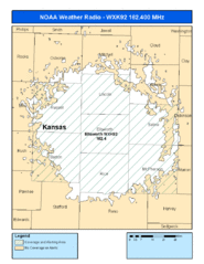
English: Coverage map for NOAA Weather radio station WXK92. |
| Source | http://www.nws.noaa.gov/nwr/Maps/PHP/site.php?State=KS&Site=WXK92 |
| Author | National Weather Service |
Licensing
This image is in the public domain because it contains materials that originally came from the U.S. National Oceanic and Atmospheric Administration, taken or made as part of an employee's official duties.
|
File history
Click on a date/time to view the file as it appeared at that time.
| Date/Time | Thumbnail | Dimensions | User | Comment | |
|---|---|---|---|---|---|
| current | 19:55, 6 July 2010 | | 816 × 1,056 (493 KB) | Ks0stm | {{Information |Description={{en|1=Coverage map for NOAA Weather radio station WXK92.}} |Source=http://www.nws.noaa.gov/nwr/Maps/PHP/site.php?State=KS&Site=WXK92 |Author=National Weather Service |Date= |Permission= |other_versions= }} [[Category:NOAA Weat |
File usage
The following page uses this file: