Jump to content

File:Vychodoslovenska pahorkatina subdivisions.png

Page contents not supported in other languages.
This is a file from the Wikimedia Commons
From Wikipedia, the free encyclopedia

Original file (671 × 684 pixels, file size: 34 KB, MIME type: image/png)

Summary

Description
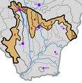
Čeština: Členění geomorfologického celku Východoslovenská pahorkatina. Schematicky jsou znázorněny též nejvýznamnější vodní toky a města.

Východoslovenská pahorkatina

  1. Podslanská pahorkatina
  2. Toplianska niva
  3. Vranovská pahorkatina
  4. Ondavská niva
  5. Pozdišovský chrbát
  6. Laborecká niva
  7. Podvihorlatská pahorkatina
  8. Zalužická pahorkatina
  9. Petrovské podhorie
řeky / rivers
Bo – Bodrog
Lb – Laborec
Lt – Latorica
On – Ondava
Ti – Tisa
To – Topľa
Uh – Uh
města / towns
Hu Humenné
KCh – Kráľovský Chlmec
Mi – Michalovce
So – Sobrance
Tr – Trebišov
VnT – Vranov nad Topľou
VK – Veľké Kapušany
Date
Source Own work, geomorphic subdivision based on Mazúr & Lukniš, 1986 (Štátny geologický ústav Dionýza Štúra)
Author User:Miaow Miaow
Permission
(Reusing this file)

PD-self

Licensing

Public domain I, the copyright holder of this work, release this work into the public domain. This applies worldwide.
In some countries this may not be legally possible; if so:
I grant anyone the right to use this work for any purpose, without any conditions, unless such conditions are required by law.

Captions

Add a one-line explanation of what this file represents

Items portrayed in this file

depicts

July 2012

File history

Click on a date/time to view the file as it appeared at that time.

Date/TimeThumbnailDimensionsUserComment
current21:49, 12 July 2012Thumbnail for version as of 21:49, 12 July 2012671 × 684 (34 KB)Miaow Miaow{{Information |Description={{cs|Členění geomorfologického celku '''Východoslovenská pahorkatina'''. Schematicky jsou znázorněny též nejvýznamnější vodní toky a mě...

The following page uses this file:

Global file usage

The following other wikis use this file:

Metadata