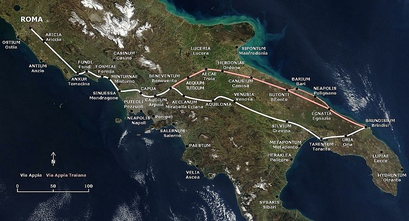
File:Via Appia map.jpg
Appearance

Size of this preview: 800 × 433 pixels. Other resolutions: 320 × 173 pixels | 640 × 346 pixels | 1,280 × 692 pixels.
Original file (1,280 × 692 pixels, file size: 599 KB, MIME type: image/jpeg)
File history
Click on a date/time to view the file as it appeared at that time.
| Date/Time | Thumbnail | Dimensions | User | Comment | |
|---|---|---|---|---|---|
| current | 17:19, 9 November 2009 |  | 1,280 × 692 (599 KB) | AlMare | Mondragone |
| 16:22, 27 July 2009 |  | 1,280 × 692 (602 KB) | AlMare | +Aequum Tuticum | |
| 18:02, 14 February 2009 |  | 1,280 × 692 (538 KB) | AlMare | Reverted to version as of 17:31, 13 July 2006 | |
| 21:03, 1 December 2008 |  | 1,280 × 692 (603 KB) | AlMare | +Sessa Aurunca | |
| 17:31, 13 July 2006 |  | 1,280 × 692 (538 KB) | AlMare | == Summary == This map is based on the following picture: Image:Satellite image of Italy in March 2003.jpg == Licensing == {{PD-self}} | |
| 17:26, 13 July 2006 |  | 1,000 × 433 (357 KB) | AlMare | This map is based on the following picture: Image:Satellite image of Italy in March 2003.jpg) |
File usage
The following 4 pages use this file:
Global file usage
The following other wikis use this file:
- Usage on af.wikipedia.org
- Usage on ar.wikipedia.org
- Usage on azb.wikipedia.org
- Usage on be.wikipedia.org
- Usage on bg.wikipedia.org
- Usage on bn.wikipedia.org
- Usage on ca.wikipedia.org
- Usage on cs.wikipedia.org
- Usage on de.wikipedia.org
- Usage on el.wikipedia.org
- Usage on en.wikivoyage.org
- Usage on eo.wikipedia.org
- Usage on es.wikipedia.org
- Usage on et.wikipedia.org
- Usage on fr.wikipedia.org
- Usage on he.wikipedia.org
- Usage on hr.wikipedia.org
- Usage on hu.wikipedia.org
- Usage on id.wikipedia.org
- Usage on it.wikipedia.org
View more global usage of this file.


