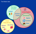
File:British Isles Venn Diagram-en (3).png
Appearance

Size of this preview: 603 × 599 pixels. Other resolutions: 242 × 240 pixels | 483 × 480 pixels | 640 × 636 pixels.
Original file (640 × 636 pixels, file size: 75 KB, MIME type: image/png)
File history
Click on a date/time to view the file as it appeared at that time.
| Date/Time | Thumbnail | Dimensions | User | Comment | |
|---|---|---|---|---|---|
| current | 12:58, 11 October 2011 |  | 640 × 636 (75 KB) | SreeBot | (Original text) : Distinguished between the two definitions of British Isles |
| 12:57, 11 October 2011 |  | 536 × 501 (58 KB) | SreeBot | (Original text) : Reverted to version as of 20:02, 24 June 2009 | |
| 12:57, 11 October 2011 |  | 536 × 501 (51 KB) | SreeBot | (Original text) : Updated per WP:VERIFY - Channel Islands are a part of the British isles | |
| 12:57, 11 October 2011 |  | 536 × 501 (58 KB) | SreeBot | (Original text) : Aesthetic changes | |
| 12:57, 11 October 2011 |  | 536 × 501 (55 KB) | SreeBot | (Original text) : {{Information |Description = Venn diagram displaying the relationships between the subsidiary nations of the UK and the meaning of the term "British Isles" and how the "Crown dependencies" fit in. |Source = Wdcf - derived fr |
File usage
The following 2 pages use this file:

