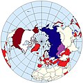
File:US and Russian bases and facilities.jpg
Appearance

Size of this preview: 600 × 600 pixels. Other resolutions: 240 × 240 pixels | 480 × 480 pixels.
Original file (800 × 800 pixels, file size: 351 KB, MIME type: image/jpeg)
File history
Click on a date/time to view the file as it appeared at that time.
| Date/Time | Thumbnail | Dimensions | User | Comment | |
|---|---|---|---|---|---|
| current | 19:13, 10 February 2023 |  | 800 × 800 (351 KB) | Goran tek-en | Georgia colored light blue as requested by Maphobbyist |
| 20:18, 9 February 2023 |  | 800 × 800 (348 KB) | Goran tek-en | Azerbaijan and Georgia edited as requested by Maphobbyist | |
| 19:55, 9 February 2023 |  | 800 × 800 (310 KB) | Goran tek-en | Added borders of South Sudan as requested by Maphobbyist | |
| 22:26, 29 April 2016 |  | 800 × 800 (237 KB) | Palu | removed Czech republic, Serbia, Macedonia, Croatia, Canada - per w:cs:Diskuse:Druhá studená válka#Oprava mapy | |
| 16:22, 27 April 2016 |  | 800 × 800 (236 KB) | Palu | removed Czech republic | |
| 09:14, 25 March 2015 |  | 800 × 800 (230 KB) | Blaue Max | Removed Senegal, Egypt and Somalia | |
| 17:38, 3 March 2015 |  | 800 × 800 (231 KB) | Blaue Max | Inverted colors per talk page | |
| 21:23, 28 February 2015 |  | 800 × 800 (226 KB) | Blaue Max | added United States Naval Support Detachment, São Paulo, Brazil | |
| 20:27, 28 February 2015 |  | 800 × 800 (226 KB) | Blaue Max | User created page with UploadWizard |
File usage
The following page uses this file:
Global file usage
The following other wikis use this file:
- Usage on ca.wikipedia.org
- Usage on cs.wikipedia.org
- Usage on es.wikipedia.org
- Usage on eu.wikipedia.org
- Usage on sr.wikipedia.org
- Usage on tr.wikipedia.org
- Usage on zh.wikipedia.org
