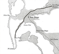
File:US Boundary Survey 1850.png
Appearance
US_Boundary_Survey_1850.png (291 × 264 pixels, file size: 66 KB, MIME type: image/png)
File history
Click on a date/time to view the file as it appeared at that time.
| Date/Time | Thumbnail | Dimensions | User | Comment | |
|---|---|---|---|---|---|
| current | 13:16, 17 October 2012 |  | 291 × 264 (66 KB) | ACP2011 | {{Information |Description ={{en|1=United States Boundary Survey, 1850, of the San Diego area.}} |Source =[http://www.laplayatrail.org/trail-markers.html La Playa Trail Association] |Author =United States Government |Date =... |
File usage
The following 4 pages use this file:

