File:USGS Hawaii Island Lava Hazard Map.gif
Appearance
USGS_Hawaii_Island_Lava_Hazard_Map.gif (323 × 341 pixels, file size: 18 KB, MIME type: image/gif)
File history
Click on a date/time to view the file as it appeared at that time.
| Date/Time | Thumbnail | Dimensions | User | Comment | |
|---|---|---|---|---|---|
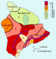
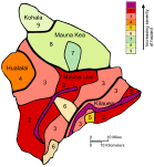
| current | 09:51, 27 May 2010 |  | 323 × 341 (18 KB) | Infanalyst | {{Information |Description={{en|1=The island of Hawaii is divided into zones according to the degree of hazard from lava flows. Zone 1 is the area of the greatest hazard, Zone 9 of the least. }} |Source=http://pubs.usgs.gov/gip/hazards/maps.html |Author=U |
File usage
The following page uses this file:
Global file usage
The following other wikis use this file:
- Usage on ja.wikipedia.org


