Jump to content

File:USGS Decorah crater.jpg

Page contents not supported in other languages.
This is a file from the Wikimedia Commons
From Wikipedia, the free encyclopedia

Original file (2,404 × 2,404 pixels, file size: 1.96 MB, MIME type: image/jpeg)

Summary

Description
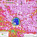
English: Recent airborne geophysical surveys near Decorah, Iowa are providing an unprecedented look at a 470- million-year-old meteorite crater concealed beneath bedrock and sediments. The recent geophysical surveys include an airborne electromagnetic system, which is sensitive to how well rocks conduct electricity, and airborne gravity gradiometry, which measures subtle changes in rock density. The surveys both confirm the earlier work and provide a new view of the Decorah Impact Structure. Models of the electromagnetic data show a crater filled with electrically conductive shale and the underlying breccia, which is rock composed of broken fragments of rock cemented together by a fine-grained matrix.
Date 27 February 2013, 23:03:42
Source

USGS resistivity map of the Decorah crater, url=http://www.usgs.gov/newsroom/article.asp?ID=3521.

Archived 2013-03-09 at the Wayback Machine. Additional archives: 2013-03-09.
Author USGS
Object location43° 18′ 06″ N, 91° 47′ 25″ W Kartographer map based on OpenStreetMap.View this and other nearby images on: OpenStreetMapinfo

Licensing

Public domain
This image is in the public domain in the United States because it only contains materials that originally came from the United States Geological Survey, an agency of the United States Department of the Interior. For more information, see the official USGS copyright policy.

Bahasa Indonesia  català  čeština  Deutsch  eesti  English  español  français  galego  italiano  Nederlands  português  polski  sicilianu  suomi  Tiếng Việt  Türkçe  български  македонски  русский  മലയാളം  한국어  日本語  中文  中文(简体)  中文(繁體)  العربية  فارسی  +/−

Original upload log

The original description page was here. All following user names refer to en.wikipedia.
  • 2013-03-07 17:11 Vkil 2404×2404× (2057822 bytes) Uploading a public-domain item using [[Wikipedia:File_Upload_Wizard|File Upload Wizard]]

Captions

Add a one-line explanation of what this file represents

Items portrayed in this file

depicts

27 February 2013

image/jpeg

2,057,822 byte

2,404 pixel

2,404 pixel

321e0f9904d1b2c359b110460100f2aa92b8c73c

43°18'6.001"N, 91°47'25.001"W

File history

Click on a date/time to view the file as it appeared at that time.

Date/TimeThumbnailDimensionsUserComment
current15:07, 28 September 2015Thumbnail for version as of 15:07, 28 September 20152,404 × 2,404 (1.96 MB)OgreBot(BOT): Uploading old version of file from en.wikipedia; originally uploaded on 2013-03-07 17:11:25 by Vkil
06:13, 31 March 2013Thumbnail for version as of 06:13, 31 March 20132,404 × 2,404 (369 KB)MarshallsumterUser created page with UploadWizard

Global file usage

Metadata