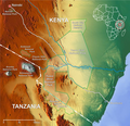
File:Tsavo national park map en.png
Appearance

Size of this preview: 620 × 600 pixels. Other resolutions: 248 × 240 pixels | 496 × 480 pixels | 1,000 × 967 pixels.
Original file (1,000 × 967 pixels, file size: 1.15 MB, MIME type: image/png)
File history
Click on a date/time to view the file as it appeared at that time.
| Date/Time | Thumbnail | Dimensions | User | Comment | |
|---|---|---|---|---|---|
| current | 14:33, 13 January 2019 |  | 1,000 × 967 (1.15 MB) | Lencer | fix scale |
| 17:14, 20 September 2007 |  | 1,000 × 963 (1.12 MB) | Lencer | ||
| 16:58, 20 September 2007 |  | 1,000 × 966 (1.12 MB) | Lencer | {{Information| |Description=Map of Tsavo East National Park and Tsavo West National Park |Source=own work, background created with [http://www.maps-for-free.com/ Google Maps-For-Free] SRTM |
File usage
The following 11 pages use this file:
Global file usage
The following other wikis use this file:
- Usage on ar.wikipedia.org
- Usage on arz.wikipedia.org
- Usage on bg.wikipedia.org
- Usage on ca.wikipedia.org
- Usage on cs.wikipedia.org
- Usage on da.wikipedia.org
- Usage on de.wikipedia.org
- Usage on eo.wikipedia.org
- Usage on es.wikipedia.org
- Usage on eu.wikipedia.org
- Usage on fa.wikipedia.org
- Usage on fi.wikipedia.org
- Usage on fr.wikipedia.org
- Usage on fr.wikivoyage.org
- Usage on hi.wikipedia.org
- Usage on hu.wikipedia.org
- Usage on id.wikipedia.org
- Usage on it.wikipedia.org
- Usage on ja.wikipedia.org
View more global usage of this file.

