File:Trekboer migration map.png
Appearance
Trekboer_migration_map.png (700 × 506 pixels, file size: 85 KB, MIME type: image/png)
File history
Click on a date/time to view the file as it appeared at that time.
| Date/Time | Thumbnail | Dimensions | User | Comment | |
|---|---|---|---|---|---|
| current | 16:22, 14 May 2020 |  | 700 × 506 (85 KB) | Hohum | Minor fix |
| 16:15, 14 May 2020 |  | 700 × 506 (84 KB) | Hohum | Cartographic colours | |
| 13:12, 5 January 2011 |  | 700 × 506 (86 KB) | Discott | Added a blank map of South Africa in the top left hand corner based on Map_of_South_Africa_with_provincial_borders.svg by Adrian Frith. | |
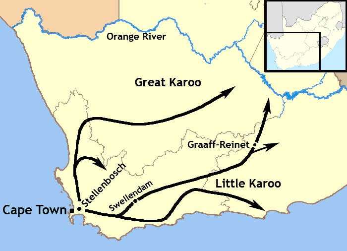
| 12:14, 5 January 2011 |  | 700 × 506 (77 KB) | Discott | {{Information |Description={{en|1=This map illustrates the migration patten of the Trekboers in what is today South Africa between 1740 and 1800.}} |Source={{own}} |Author=Discott |Date=2011-01-05 |Permission= |other_versions= }} [[Categ |
File usage
The following 3 pages use this file:
Global file usage
The following other wikis use this file:
- Usage on da.wikipedia.org
- Usage on de.wikipedia.org
- Usage on fr.wikipedia.org
- Usage on he.wikipedia.org
- Usage on ja.wikipedia.org
- Usage on no.wikipedia.org
- Usage on ru.wikipedia.org
- Usage on tum.wikipedia.org
- Usage on www.wikidata.org

