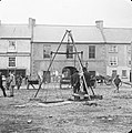
File:Town scales, in the market square, Donegal town (22352876126).jpg

Original file (1,988 × 2,000 pixels, file size: 2.18 MB, MIME type: image/jpeg)
| This is a file from the Wikimedia Commons. Information from its description page there is shown below. Commons is a freely licensed media file repository. You can help. |
Summary
| DescriptionTown scales, in the market square, Donegal town (22352876126).jpg |
Today we have an image from a collection I have not personally come across before - so for those also new to the collection, let me introduce Joshua H. Hargrave. Those who have followed the stream for a while may know that Joshua was an engineer with the Great Northern Railway and a keen amateur photographer. This is a fine shot of his of the scales in Donegal Town. Which, with thanks to [/photos/129555378@N07/ sharon.corbet], [/photos/8468254@N02/ derangedlemur] and [/photos/72163146@N08/ mcginley2012], we now know a lot more about (including location and use - see below). Also thanks to [/photos/91549360@N03/ O Mac] and [/photos/129555378@N07/ sharon.corbet] for the information on the "bakers and confectioners" pictured on the left. As [/photos/beachcomberaustralia/ beachcomberaustralia] points out, we may be able to find out a more specific date from the posters pictured next to the arch. Which local [/photos/72163146@N08/ mcginley2012] tells us lead to the Market Hall... Author: Joshua H. Hargrave (ca. 1860-1924; phtographer) Collection: Joshua H. Hargrave Collection Date: c.1890 NLI Ref: HAR3 You can also view this image, and many thousands of others, on the NLI’s catalogue at catalogue.nli.ie |
| Date |
circa |
| Source | Town scales, in the market square, Donegal town |
| Author | National Library of Ireland on The Commons |
| Permission (Reusing this file) |
National Library of Ireland on The Commons @ Flickr Commons |
| Camera location | 54° 39′ 13.06″ N, 8° 06′ 38.13″ W | View this and other nearby images on: OpenStreetMap |
|---|
Licensing
This image was taken from Flickr's The Commons. The uploading organization may have various reasons for determining that no known copyright restrictions exist, such as: No known copyright restrictionsNo restrictionshttps://www.flickr.com/commons/usage/false
More information can be found at https://flickr.com/commons/usage/. Please add additional copyright tags to this image if more specific information about copyright status can be determined. See Commons:Licensing for more information. |
| This image was originally posted to Flickr by National Library of Ireland on The Commons at https://flickr.com/photos/47290943@N03/22352876126. It was reviewed on 17 September 2016 by FlickreviewR and was confirmed to be licensed under the terms of the No known copyright restrictions. |
17 September 2016
Captions
Items portrayed in this file
depicts
some value
54°39'13.064"N, 8°6'38.131"W
0.19999973589549913109 second
14
120 millimetre
File history
Click on a date/time to view the file as it appeared at that time.
| Date/Time | Thumbnail | Dimensions | User | Comment | |
|---|---|---|---|---|---|
| current | 02:08, 17 September 2016 |  | 1,988 × 2,000 (2.18 MB) | Vanished Account Byeznhpyxeuztibuo | Transferred from Flickr via Flickr2Commons |
File usage
The following page uses this file:
Metadata
This file contains additional information, probably added from the digital camera or scanner used to create or digitize it.
If the file has been modified from its original state, some details may not fully reflect the modified file.
| Camera manufacturer | Phase One |
|---|---|
| Camera model | P65+ |
| Exposure time | 151,455/757,276 sec (0.1999997358955) |
| F-number | f/14 |
| ISO speed rating | 50 |
| Date and time of data generation | 11:15, 15 July 2011 |
| Lens focal length | 120 mm |
| Width | 4,679 px |
| Height | 4,709 px |
| Bits per component |
|
| Compression scheme | Uncompressed |
| Pixel composition | RGB |
| Orientation | Normal |
| Number of components | 3 |
| Horizontal resolution | 600 dpi |
| Vertical resolution | 600 dpi |
| Data arrangement | chunky format |
| Software used | Adobe Photoshop CS3 Windows |
| File change date and time | 18:15, 2 October 2015 |
| Exposure Program | Manual |
| Exif version | 2.2 |
| Date and time of digitizing | 11:15, 15 July 2011 |
| Shutter speed | 2.32193 |
| APEX aperture | 7.6147 |
| Exposure bias | 0 |
| Light source | Other light source |
| Color space | Uncalibrated |
| File source | Digital still camera |
| Scene type | A directly photographed image |
| Image width | 1,988 px |
| Image height | 2,000 px |
| Date metadata was last modified | 19:15, 2 October 2015 |
| IIM version | 4 |
