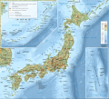
File:Topographic map Japan-en.svg
Appearance

Size of this PNG preview of this SVG file: 661 × 600 pixels. Other resolutions: 265 × 240 pixels | 529 × 480 pixels | 846 × 768 pixels | 1,129 × 1,024 pixels | 2,257 × 2,048 pixels | 2,322 × 2,107 pixels.
Original file (SVG file, nominally 2,322 × 2,107 pixels, file size: 3.29 MB)
File history
Click on a date/time to view the file as it appeared at that time.
| Date/Time | Thumbnail | Dimensions | User | Comment | |
|---|---|---|---|---|---|
| current | 19:58, 5 May 2016 |  | 2,322 × 2,107 (3.29 MB) | Bamse | update Kure and Sasebo to core city status |
| 20:18, 2 May 2016 |  | 2,322 × 2,107 (3.29 MB) | Bamse | some cosmetic changes | |
| 20:18, 1 May 2016 |  | 2,322 × 2,107 (3.29 MB) | Bamse | {{Information |Description ={{en|1=Topographic and administrative map of Japan in English language. }} {{de|1=Topographische Karte / StraßenkarteJapans, in Englisch.}} |Source ={{AttribSVG|Carte_topographiq... |
File usage
The following page uses this file:
Global file usage
The following other wikis use this file:
- Usage on gl.wikipedia.org
- Usage on it.wikipedia.org
- Usage on lmo.wikipedia.org
- Usage on mt.wikipedia.org
- Usage on uk.wikipedia.org

