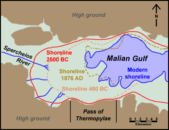
File:Thermopylae shoreline changes map.png
Appearance
Thermopylae_shoreline_changes_map.png (542 × 417 pixels, file size: 88 KB, MIME type: image/png)
File history
Click on a date/time to view the file as it appeared at that time.
| Date/Time | Thumbnail | Dimensions | User | Comment | |
|---|---|---|---|---|---|
| current | 08:27, 12 June 2011 |  | 542 × 417 (88 KB) | Cplakidas | minor corrections on names |
| 00:00, 1 October 2008 |  | 542 × 417 (31 KB) | ChrisO | {{Information |Description={{en|1=Map of Thermopylae area with modern shoreline and reconstructed shorelines of 1872 AD, 480 BC and 2500 BC. Loosely based on figure 3.19 in ''Geoarchaeology: The Earth-science Approach to Archaeological Interpretation'', p |
File usage
The following 2 pages use this file:
Global file usage
The following other wikis use this file:
- Usage on ar.wikipedia.org
- Usage on azb.wikipedia.org
- Usage on br.wikipedia.org
- Usage on ca.wikipedia.org
- Usage on da.wikipedia.org
- Usage on de.wikipedia.org
- Usage on el.wikipedia.org
- Usage on fi.wikipedia.org
- Usage on fr.wikipedia.org
- Usage on hr.wikipedia.org
- Usage on hu.wikipedia.org
- Usage on id.wikipedia.org
- Usage on la.wikipedia.org
- Usage on mk.wikipedia.org
- Usage on ru.wikipedia.org
- Usage on sh.wikipedia.org
- Usage on simple.wikipedia.org
- Usage on sl.wikipedia.org
- Usage on sr.wikipedia.org
- Usage on tr.wikipedia.org
- Usage on uk.wikipedia.org
- Usage on vi.wikipedia.org
- Usage on zh.wikipedia.org

