
File:Tehsil Mullagori Map.jpg

Size of this preview: 800 × 523 pixels. Other resolutions: 320 × 209 pixels | 640 × 418 pixels | 1,024 × 669 pixels | 1,280 × 837 pixels | 2,692 × 1,760 pixels.
Original file (2,692 × 1,760 pixels, file size: 627 KB, MIME type: image/jpeg)
| This is a file from the Wikimedia Commons. Information from its description page there is shown below. Commons is a freely licensed media file repository. You can help. |
Summary
| Description |
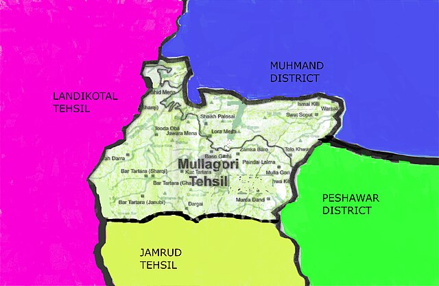
English: This detailed map illustrates the boundaries of Tehsil Mullagori, highlighting its strategic position as it intersects with Tehsil Jamrud, Tehsil Landikotal, Peshawar District, and Mohmand District.
اردو: یہ تفصیلی نقشہ تحصیل ملاگوری کی حدود کو واضح کرتا ہے، جو کہ تحصیل جمرود، تحصیل لنڈی کوتل، ضلع پشاور، اور ضلع مہمند سے ملتے ہوئے اس کی اسٹریٹجک پوزیشن کو نمایاں کرتا ہے۔
پښتو: دا مفصل نقشه د ملاګوري تحصیل سرحدونه په ګوته کوي، د دې ستراتیژیک موقعیت په ګوته کوي ځکه چې دا تحصیل جمرود، تحصیل لینډی کوتل، د پیښور ولسوالۍ، او مهمند ولسوالۍ سره یو ځای کیږي. |
| Date | |
| Source | Own work |
| Author | Javed Ullah MGI (MullaGHORI) |
Licensing
I, the copyright holder of this work, hereby publish it under the following license:
| This file is made available under the Creative Commons CC0 1.0 Universal Public Domain Dedication. | |
| The person who associated a work with this deed has dedicated the work to the public domain by waiving all of their rights to the work worldwide under copyright law, including all related and neighboring rights, to the extent allowed by law. You can copy, modify, distribute and perform the work, even for commercial purposes, all without asking permission.
|
File history
Click on a date/time to view the file as it appeared at that time.
| Date/Time | Thumbnail | Dimensions | User | Comment | |
|---|---|---|---|---|---|
| current | 17:12, 9 March 2024 | | 2,692 × 1,760 (627 KB) | Javed Ullah MGI (MullaGHORI) | Uploaded own work with UploadWizard |
File usage
The following page uses this file: