Jump to content

File:Tasman Lake - panoramic view from near its outlet.jpg

Page contents not supported in other languages.
This is a file from the Wikimedia Commons
From Wikipedia, the free encyclopedia

Original file (8,772 × 3,759 pixels, file size: 10.55 MB, MIME type: image/jpeg)

Summary

Description
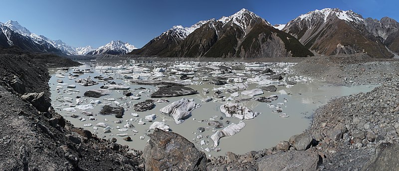
English: Tasman Lake, as seen from near its outlet (far right). Tasman Glacier can be seen across the lake, in the distance on the left. Its lower reaches are mantled with rock debris, as are several of the icebergs in the lake. Two tour boats can be seen in this direction, near a large white iceberg. The glacier's barren lateral and terminal moraines line the rest of the lake's coastline, and the Murchison River has cut an entrance through the lateral moraine opposite this viewpoint. Aoraki / Mount Cook (New Zealand's tallest mountain) is the high peak at far left, and the Minarets are visible in the distance above the glacier.
Date
Source Own work
Author Avenue
Camera location43° 42′ 20.52″ S, 170° 10′ 14.52″ E  Heading=67.5° Kartographer map based on OpenStreetMap.View this and other nearby images on: OpenStreetMapinfo
This is a retouched picture, which means that it has been digitally altered from its original version. Modifications: Stiched together from 5 photos; corners filled in.

NOTE: This image is a panorama consisting of multiple frames that were merged or stitched in software. As a result, this image necessarily underwent some form of digital manipulation. These manipulations may include blending, blurring, cloning, and colour and perspective adjustments. As a result of these adjustments, the image content may be slightly different from reality at the points where multiple images were combined. This manipulation is often required due to lens, perspective, and parallax distortions.

Boarisch | български | dansk | Deutsch | Zazaki | Ελληνικά | English | Canadian English | British English | Esperanto | español | eesti | suomi | français | hrvatski | magyar | italiano | 日本語 | 한국어 | македонски | മലയാളം | Nederlands | polski | português | русский | sicilianu | slovenščina | svenska | Türkçe | українська | العربية | 中文 | +/−

Licensing

I, the copyright holder of this work, hereby publish it under the following licenses:
w:en:Creative Commons
attribution share alike
This file is licensed under the Creative Commons Attribution-Share Alike 3.0 Unported license.
You are free:
  • to share – to copy, distribute and transmit the work
  • to remix – to adapt the work
Under the following conditions:
  • attribution – You must give appropriate credit, provide a link to the license, and indicate if changes were made. You may do so in any reasonable manner, but not in any way that suggests the licensor endorses you or your use.
  • share alike – If you remix, transform, or build upon the material, you must distribute your contributions under the same or compatible license as the original.
GNU head Permission is granted to copy, distribute and/or modify this document under the terms of the GNU Free Documentation License, Version 1.2 or any later version published by the Free Software Foundation; with no Invariant Sections, no Front-Cover Texts, and no Back-Cover Texts. A copy of the license is included in the section entitled GNU Free Documentation License.
You may select the license of your choice.
Annotations
InfoField
This image is annotated: View the annotations at Commons

Captions

Add a one-line explanation of what this file represents

Items portrayed in this file

depicts

5 October 2010

43°42'20.5"S, 170°10'14.5"E

heading: 67.5 degree

11,065,057 byte

3,759 pixel

8,772 pixel

image/jpeg

febdda5e45bbe60b827a7fd9221c54bf38e56cce

File history

Click on a date/time to view the file as it appeared at that time.

Date/TimeThumbnailDimensionsUserComment
current16:07, 22 February 2011Thumbnail for version as of 16:07, 22 February 20118,772 × 3,759 (10.55 MB)AvenueFix "hole" along bottom edge.
07:57, 4 November 2010Thumbnail for version as of 07:57, 4 November 20108,772 × 3,759 (10.56 MB)Avenue{{Information |Description={{myv|1=Tasman Lake, as seen from near its outlet (far right). Tasman Glacier can be seen across the lake, in the distance on the left. Its lower reaches are mantled with rock debris, as are many of the icebergs in the lake. Two

Global file usage

The following other wikis use this file: