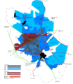
File:Swindon urban growth.png
Appearance

Size of this preview: 523 × 600 pixels. Other resolutions: 209 × 240 pixels | 419 × 480 pixels | 670 × 768 pixels | 1,100 × 1,261 pixels.
Original file (1,100 × 1,261 pixels, file size: 80 KB, MIME type: image/png)
File history
Click on a date/time to view the file as it appeared at that time.
| Date/Time | Thumbnail | Dimensions | User | Comment | |
|---|---|---|---|---|---|
| current | 10:11, 19 December 2006 |  | 1,100 × 1,261 (80 KB) | Foxhill | == Summary == {{Information |Description=Diagram of the Swindon Urban Area growth 1800-1965 |Source=Own work |Author=Foxhill |Permission=All Rights Released |Date=2006-12-19 }} Updated to fix East/West placename errors and add road names. Taking data fr |
| 08:07, 19 December 2006 |  | 1,100 × 1,261 (77 KB) | Foxhill | {{Information |Description=Diagram of the Swindon Urban Area growth 1800-1965 |Source=Own work |Date=2006-12-19 }} Taking data from - *{{cite book | title=A History of Swindon to 1965| author=Elizabeth Crittal | coauthors=K.H. Rogers, Colin Shrimpton| d |
File usage
The following 2 pages use this file:
