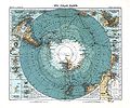
File:Sud Polar Karte.jpg
Appearance

Size of this preview: 718 × 599 pixels. Other resolutions: 288 × 240 pixels | 575 × 480 pixels | 920 × 768 pixels | 1,227 × 1,024 pixels | 2,453 × 2,048 pixels | 5,598 × 4,673 pixels.
Original file (5,598 × 4,673 pixels, file size: 4.23 MB, MIME type: image/jpeg)
File history
Click on a date/time to view the file as it appeared at that time.
| Date/Time | Thumbnail | Dimensions | User | Comment | |
|---|---|---|---|---|---|
| current | 19:30, 29 April 2009 |  | 5,598 × 4,673 (4.23 MB) | Alex:D | {{Information |Description={{en|1=Map of Antarctica. Scale [ca. 1:40,000,000]. Col., 34 x 41 cm.}} |Source={{LOC-map|id=g9800.ct000774}}, Stieler's Hand-Atlas, No. 6 |Author=Petermann, A. |Date=1912 |Permission= |other_versions= }} <!--{{ImageUpload|fu |
File usage
The following page uses this file:
Global file usage
The following other wikis use this file:
- Usage on az.wikipedia.org
- Usage on fr.wikipedia.org
- Usage on it.wikipedia.org
- Usage on ro.wikipedia.org
- Usage on ru.wikipedia.org

