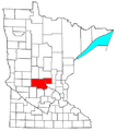
File:St. Cloud Metropolitan Area.png
Appearance
St._Cloud_Metropolitan_Area.png (440 × 498 pixels, file size: 24 KB, MIME type: image/png)
File history
Click on a date/time to view the file as it appeared at that time.
| Date/Time | Thumbnail | Dimensions | User | Comment | |
|---|---|---|---|---|---|
| current | 19:36, 30 July 2008 |  | 440 × 498 (24 KB) | Nyttend | {{Information |Description=Locator map of the {{w|St. Cloud, MN MSA|St. Cloud Metropolitan Statistical Area}} in the central part of the {{w|U.S. state}} of {{w|Minnesota}}. |Source=Modified from [http://www2.census.gov/geo/maps/general_ref/cousub_outline |
File usage
The following 42 pages use this file:
- Albany, Minnesota
- Avon, Minnesota
- Belgrade, Minnesota
- Benton County, Minnesota
- Brooten, Minnesota
- Clearwater, Minnesota
- Cold Spring, Minnesota
- Eden Valley, Minnesota
- Elrosa, Minnesota
- Fairhaven, Minnesota
- Foley, Minnesota
- Freeport, Minnesota
- Gilman, Minnesota
- Greenwald, Minnesota
- Holdingford, Minnesota
- Kimball, Minnesota
- Lake Henry, Minnesota
- Meire Grove, Minnesota
- Melrose, Minnesota
- New Munich, Minnesota
- Paynesville, Minnesota
- Rice, Minnesota
- Richmond, Minnesota
- Rockville, Minnesota
- Ronneby, Minnesota
- Roscoe, Minnesota
- Royalton, Minnesota
- Sauk Centre, Minnesota
- Sauk Rapids, Minnesota
- Spring Hill, Minnesota
- St. Anthony, Stearns County, Minnesota
- St. Augusta, Minnesota
- St. Cloud, Minnesota
- St. Cloud, Minnesota metropolitan area
- St. Joseph, Minnesota
- St. Martin, Minnesota
- St. Rosa, Minnesota
- St. Stephen, Minnesota
- Stearns County, Minnesota
- Waite Park, Minnesota
- User:Zpro1408/sandbox
- Template:St. Cloud metropolitan area
Global file usage
The following other wikis use this file:
- Usage on es.wikipedia.org
- Usage on www.wikidata.org

