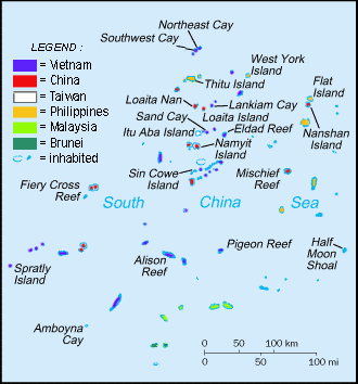
File:Spratly Is since NalGeoMaps.png
Appearance
Spratly_Is_since_NalGeoMaps.png (330 × 354 pixels, file size: 31 KB, MIME type: image/png)
File history
Click on a date/time to view the file as it appeared at that time.
| Date/Time | Thumbnail | Dimensions | User | Comment | |
|---|---|---|---|---|---|
| current | 06:50, 12 March 2021 |  | 330 × 354 (31 KB) | Mlgc1998 | typo |
| 11:46, 13 April 2015 |  | 330 × 354 (18 KB) | RokerHRO | optipng -o7 -i0 → 42.83% decrease | |
| 14:05, 29 March 2009 |  | 330 × 354 (32 KB) | Spiridon Ion Cepleanu | {{Information |Description={{en|1=Spratley Islands military settlements}} {{fr|1=Etablissements militaires dans l'archipel des Spratly}} |Source=Cartothèque Spiridon Manoliu |Author=Spiridon Manoliu |Date=March 29, 2009 |Permission= |other_versions= }} |
File usage
The following 12 pages use this file:
- DK1 rigs
- Dangerous Ground (South China Sea)
- East Sea Campaign
- Exclusive economic zone
- Great Wall of Sand
- List of airports in the Spratly Islands
- List of maritime features in the Spratly Islands
- Philippines and the Spratly Islands
- Republic of Morac-Songhrati-Meads
- Spratly Islands
- Spratly Islands dispute
- Template:Spratly Islands
Global file usage
The following other wikis use this file:
- Usage on bcl.wikipedia.org
- Usage on br.wikipedia.org
- Usage on cs.wikipedia.org
- Usage on de.wikipedia.org
- Usage on el.wikipedia.org
- Usage on en.wikinews.org
- Usage on en.wikivoyage.org
- Usage on fa.wikipedia.org
- Usage on fi.wikipedia.org
- Usage on fr.wikipedia.org
- Usage on fr.wiktionary.org
- Usage on gl.wikipedia.org
- Usage on hi.wikipedia.org
- Usage on id.wikipedia.org
- Usage on io.wikipedia.org
- Usage on ja.wikipedia.org
- Usage on ko.wikipedia.org
- Usage on no.wikipedia.org
- Usage on pt.wikipedia.org
- Usage on sv.wikipedia.org
- Usage on th.wikipedia.org
- Usage on tr.wikipedia.org
- Usage on ug.wikipedia.org
- Usage on vi.wikipedia.org


