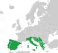
File:Southern Europe map green.png
Appearance

Size of this preview: 655 × 599 pixels. Other resolutions: 262 × 240 pixels | 525 × 480 pixels | 839 × 768 pixels | 1,118 × 1,023 pixels.
Original file (1,118 × 1,023 pixels, file size: 78 KB, MIME type: image/png)
File history
Click on a date/time to view the file as it appeared at that time.
| Date/Time | Thumbnail | Dimensions | User | Comment | |
|---|---|---|---|---|---|
| current | 14:52, 6 August 2022 |  | 1,118 × 1,023 (78 KB) | Рагин1987 | Like it or not, East Thrace is geographically part of Southeast Europe (Balkan Peninsula) |
| 00:03, 10 June 2020 |  | 1,118 × 1,023 (151 KB) | Maphobbyist | Cyprus is not geographically part of Europe. Removed Turkey, because only whole countries are included. | |
| 08:08, 7 January 2020 |  | 1,118 × 1,023 (163 KB) | Vesperius | European Turkey included and Corsica excluded. | |
| 18:35, 26 July 2016 |  | 1,118 × 1,023 (151 KB) | Paasikivi | new version (correcting) | |
| 18:29, 26 July 2016 |  | 1,118 × 1,023 (151 KB) | Paasikivi | User created page with UploadWizard |
File usage
The following page uses this file:
Global file usage
The following other wikis use this file:
- Usage on am.wikipedia.org
- Usage on beta.wikiversity.org
- Usage on eu.wikipedia.org
- Usage on fa.wikipedia.org
- Usage on fi.wikipedia.org
- Usage on sd.wikipedia.org
- Usage on vi.wikipedia.org
