
File:Somers town 1837.jpg
No higher resolution available.
Somers_town_1837.jpg (747 × 546 pixels, file size: 208 KB, MIME type: image/jpeg)
Summary
[edit]
| Description |
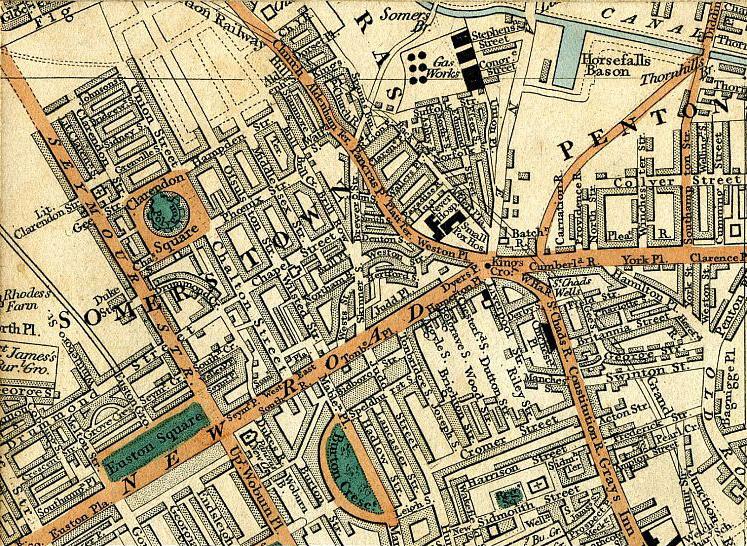
Cary's New Plan Of London And Its Vicinity 1837 - map showing Pancras, Regent's Canal, Clarendon Square, Somers Town, Pentonville, King's Cross and Euston Square | ||
|---|---|---|---|
| Source | |||
| Date |
1837 | ||
| Author |
| ||
| Permission (Reusing this file) |
See below.
|
Licensing
[edit]
| This image is in the public domain in the United States. In most cases, this means that it was first published prior to January 1, 1929 (see the template documentation for more cases). Other jurisdictions may have other rules, and this image might not be in the public domain outside the United States. See Wikipedia:Public domain and Wikipedia:Copyrights for more details. |
 | This file is a candidate to be copied to Wikimedia Commons.
Any user may perform this transfer; refer to Wikipedia:Moving files to Commons for details. If this file has problems with attribution, copyright, or is otherwise ineligible for Commons, then remove this tag and DO NOT transfer it; repeat violators may be blocked from editing. Other Instructions
| ||
| |||
File history
Click on a date/time to view the file as it appeared at that time.
| Date/Time | Thumbnail | Dimensions | User | Comment | |
|---|---|---|---|---|---|
| current | 20:44, 26 September 2010 | | 747 × 546 (208 KB) | SasiSasi (talk | contribs) | {{Information |Description = Cary's New Plan Of London And Its Vicinity 1837 - map showing Pancras, Regent's Canal, Clarendon Square, Somers Town, Pentonville, Kings Cross and Euston Square |Source = http://archivemaps.com/mapco/cary1837/cary |
You cannot overwrite this file.
File usage
The following 2 pages use this file: