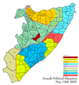
File:Somali land 2007 05 18.png
Appearance

Size of this preview: 555 × 599 pixels. Other resolutions: 222 × 240 pixels | 444 × 480 pixels | 711 × 768 pixels | 948 × 1,024 pixels | 1,400 × 1,512 pixels.
Original file (1,400 × 1,512 pixels, file size: 91 KB, MIME type: image/png)
File history
Click on a date/time to view the file as it appeared at that time.
| Date/Time | Thumbnail | Dimensions | User | Comment | |
|---|---|---|---|---|---|
| current | 06:15, 19 May 2007 |  | 1,400 × 1,512 (91 KB) | Ingoman | |
| 06:04, 19 May 2007 |  | 1,400 × 1,512 (91 KB) | Ingoman | {{Information |Description=Map of Somali Territories as of May 18th 2007, with the latest territorial exchanges in the various conflicts. |Source=self-made |Date=May 18th 2007 |Author= User:Ingoman }} |
File usage
The following 4 pages use this file:
Global file usage
The following other wikis use this file:
- Usage on ast.wikipedia.org
- Usage on ca.wikipedia.org
- Usage on cy.wikipedia.org
- Usage on de.wikipedia.org
- Usage on es.wikipedia.org
- Usage on fr.wikipedia.org
- Usage on gl.wikipedia.org
- Usage on it.wikipedia.org
- Usage on nl.wikipedia.org
- Usage on www.wikidata.org
