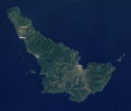
File:Skopelos satellite map.png
Appearance

Size of this preview: 703 × 599 pixels. Other resolutions: 282 × 240 pixels | 563 × 480 pixels | 745 × 635 pixels.
Original file (745 × 635 pixels, file size: 887 KB, MIME type: image/png)
File history
Click on a date/time to view the file as it appeared at that time.
| Date/Time | Thumbnail | Dimensions | User | Comment | |
|---|---|---|---|---|---|
| current | 14:12, 11 September 2009 |  | 745 × 635 (887 KB) | No such user | == Summary == {{Information |Description={{en|1=Satellite image of Skopelos, Greek island in the Aegean sea}} |Source=Screenshot from NASA WorldWind software |Author=User: No such user |Date=2009-09-11 |Permission= |other_versions= }} == [[Commons:Copyri |
File usage
The following 2 pages use this file:
Global file usage
The following other wikis use this file:
- Usage on ar.wikipedia.org
- Usage on bg.wikipedia.org
- Usage on da.wikipedia.org
- Usage on de.wikipedia.org
- Usage on el.wikipedia.org
- Usage on es.wikipedia.org
- Usage on fi.wikipedia.org
- Usage on fo.wikipedia.org
- Usage on it.wikipedia.org
- Usage on mk.wikipedia.org
- Usage on no.wikipedia.org
- Usage on pl.wikipedia.org
- Usage on pl.wikivoyage.org
- Usage on pt.wikipedia.org
- Usage on sv.wikipedia.org
- Usage on zh.wikipedia.org


