Jump to content

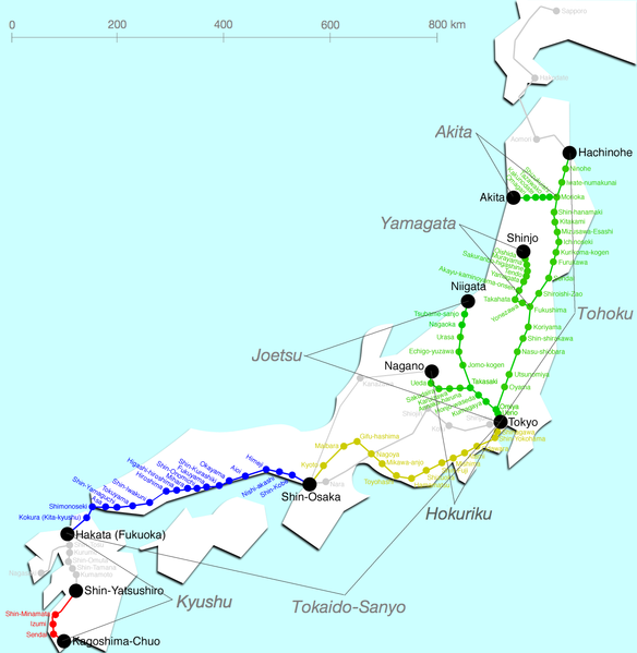
File:Shinkansenmap.png

Page contents not supported in other languages.
This is a file from the Wikimedia Commons
From Wikipedia, the free encyclopedia

Original file (1,345 × 1,380 pixels, file size: 239 KB, MIME type: image/png)

Description
English: Map of Shinkansen network.

Please don't use this image because this includes some errors.

  • ”Akayu kaminoyama onsen" station on this map are two stations: "Kaminoyama Onsen" station and "Akayu" station.
  • "Kakegawa" station is not in this image.
  • "Chikugo Funagoya" station will open between Kurume and Shin Omuta.
Deutsch: Streckennetz des Shinkansen
Suomi: Kartta, johon Tōkaidō Shinkansen on merkitty keltaisella.
Italiano: Shinkansen mappa delle linee
Nederlands: Kaart van de lijnen
Polski: Mapa sieci kolejowej Shinkansen
Date Unknown date
Source en:Image:Shinkansenmap.png
Author Sekicho
Permission
(Reusing this file)
Public domain This work has been released into the public domain by its author, Sekicho at English Wikipedia. This applies worldwide.
In some countries this may not be legally possible; if so:
Sekicho grants anyone the right to use this work for any purpose, without any conditions, unless such conditions are required by law.
Other versions de:Bild:Shinkansen-Liniennetz.jpg
This transport map image could be re-created using vector graphics as an SVG file. This has several advantages; see Commons:Media for cleanup for more information. If an SVG form of this image is available, please upload it and afterwards replace this template with {{vector version available|new image name}}.


It is recommended to name the SVG file “Shinkansenmap.svg”—then the template Vector version available (or Vva) does not need the new image name parameter.

Captions

Add a one-line explanation of what this file represents

Items portrayed in this file

depicts

File history

Click on a date/time to view the file as it appeared at that time.

Date/TimeThumbnailDimensionsUserComment
current23:52, 6 December 2005Thumbnail for version as of 23:52, 6 December 20051,345 × 1,380 (239 KB)Wiki-vr*Map of Shinkansen network *Karte des japanischen Shinkansen-Netzes *source: en:Image:Shinkansenmap.png *info added {{PD}} Category:Maps of Japan Category:Railroad map of Japan category:Shinkansen

The following page uses this file:

Global file usage

The following other wikis use this file: