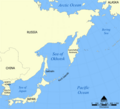
File:Sea of Okhotsk map with state labels.png
Appearance

Size of this preview: 657 × 599 pixels. Other resolutions: 263 × 240 pixels | 526 × 480 pixels | 990 × 903 pixels.
Original file (990 × 903 pixels, file size: 84 KB, MIME type: image/png)
File history
Click on a date/time to view the file as it appeared at that time.
| Date/Time | Thumbnail | Dimensions | User | Comment | |
|---|---|---|---|---|---|
| current | 17:13, 23 April 2010 |  | 990 × 903 (84 KB) | Ras67 | cropped |
| 10:58, 4 August 2007 |  | 1,000 × 913 (85 KB) | Nihad Hamzic | Greatly reduced file size by removing the alpha channel, what enabled me to losslessly reduce the color domain do 8-bit. If alpha channel is indeed needed, then revert this image. | |
| 15:40, 24 October 2005 |  | 1,000 × 913 (408 KB) | NormanEinstein | This is a map showing the location of the Sea of Okhotsk. The sea is bordered by Russia and Japan. Created by NormanEinstein, October 24, 2005. {{GFDL-self}} Category:Maps of seas |
File usage
The following 9 pages use this file:
Global file usage
The following other wikis use this file:
- Usage on ace.wikipedia.org
- Usage on af.wikipedia.org
- Usage on als.wikipedia.org
- Usage on ar.wikipedia.org
- Usage on ast.wikipedia.org
- Usage on avk.wikipedia.org
- Usage on azb.wikipedia.org
- Usage on az.wikipedia.org
- Usage on az.wiktionary.org
- Usage on bat-smg.wikipedia.org
- Usage on be-tarask.wikipedia.org
- Usage on be.wikipedia.org
- Usage on bg.wikipedia.org
- Usage on bn.wikipedia.org
- Usage on br.wikipedia.org
- Usage on bxr.wikipedia.org
- Usage on ca.wikipedia.org
- Usage on ca.wikinews.org
- Usage on ckb.wikipedia.org
- Usage on cs.wikipedia.org
- Usage on cy.wikipedia.org
- Usage on da.wikipedia.org
- Usage on de.wikipedia.org
- Usage on dsb.wikipedia.org
- Usage on el.wikipedia.org
- Usage on en.wikinews.org
- Usage on eo.wikipedia.org
- Usage on eo.wikiquote.org
- Usage on es.wikipedia.org
View more global usage of this file.


