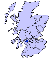
File:ScotlandRenfrewshire.png
Appearance
ScotlandRenfrewshire.png (200 × 230 pixels, file size: 4 KB, MIME type: image/png)
File history
Click on a date/time to view the file as it appeared at that time.
| Date/Time | Thumbnail | Dimensions | User | Comment | |
|---|---|---|---|---|---|
| current | 21:48, 17 May 2005 |  | 200 × 230 (4 KB) | Voyager | |
| 21:47, 17 May 2005 |  | 200 × 230 (4 KB) | Voyager | Renfrewshire unitary council Slightly edited version of a map drawn by Morwen {{GFDL}} Category:Maps of Scottish unitary councils |
File usage
The following 3 pages use this file:
Global file usage
The following other wikis use this file:
- Usage on be.wikipedia.org
- Usage on bg.wikipedia.org
- Usage on cy.wikipedia.org
- Usage on de.wikipedia.org
- Usage on eu.wikipedia.org
- Renfrewshire
- Lankide:Euskaldunaa
- Paisley
- Renfrew
- Txantiloi:Renfrewshire
- Wikiproiektu:Irlanda, Gales eta Eskoziako udalerriak
- Johnstone
- Erskine
- Linwood (Renfrewshire)
- Bishopton (Renfrewshire)
- Ralston (Renfrewshire)
- Bridge of Weir
- Brookfield (Renfrewshire)
- Craigends
- Crosslee
- Elderslie
- Houston (Renfrewshire)
- Howwood
- Inchinnan
- Kilbarchan
- Langbank
- Lochwinnoch
- Ranfurly (Renfrewshire)
- Usage on ga.wikipedia.org
- Usage on gd.wikipedia.org
- Usage on no.wikipedia.org
- Usage on pt.wikipedia.org
- Usage on sv.wikipedia.org
- Usage on uk.wikipedia.org
- Usage on www.wikidata.org


